I hereby summarize this historical excerpt about the origins of the term “Talaing,” its relation to the Chola Dynasty, and maritime trade on the peninsula.
Here is the detailed English translation of the provided text:
“Talaing / Tanlai / Tanling”
In various historical records, the term “Talaing” appears as “Tanlai” or “Tanling.” When hearing the term “Talaing,” most people immediately associate it with the Mon people. However, the Mon themselves strongly dislike being called “Talaing”—a sentiment that is historically justified.
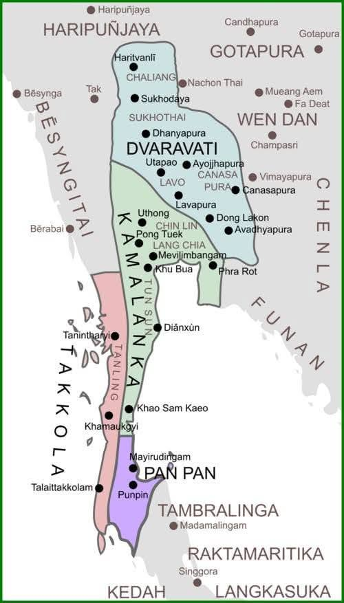
The terms Tanling / Tanlai / Tanling originated not as the name of an ethnic group, but as the geographic name of a trading port city called Talaitakkoklam (present-day Takola), located in the Tanling region (present-day Talatyai) on the peninsula of Southern Thailand, just beyond the southernmost tip of Myanmar. In the early 11th century, due to the territorial expansion of the Tamil Chola Empire and the Angkorian Empire, the influence of this regional designation expanded all the way north to Pegu (Bago).
This early port city in Southern Thailand, beyond Kawthaung, was built and inhabited by a diverse population: Bamar (Burman) people from the Tenasserim region (Dawei and Myeik), Malays, Mons, and the Munda people—an Austroasiatic group originating from India with close ethnolinguistic ties to the Mon. Though originally a narrow and relatively small coastal outpost, it played an early role in maritime commerce.
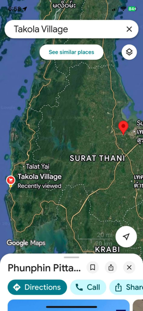
According to Tamil Chola records and inscriptions, in 1030 AD, the Chola King Rajendra I launched a naval campaign in Southeast Asia to attack the Srivijaya and Tambralinga kingdoms. Talaitakkoklam was the very first city targeted by the Chola navy, subsequently serving as the Chola military’s first operational base in Southeast Asia.
Centering their campaign at this base in Tambralinga and Talaitakkoklam, the Tamil Chola empire—supported by local subjects (Munda, Mon, and Malay populations of Talaitakkoklam and Tambralinga) alongside their Angkorian Khmer and Cham allies—conquered territories stretching from Srivijaya across the Malay Peninsula up into Lower Myanmar, controlling nearly the entire Pegu (Bago) region.
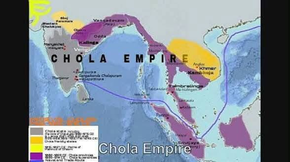
Until the reign of King Anawrahta of Pagan, Lower Myanmar and Pegu remained under the control of Chola-vassal forces comprised of Munda, Malay, Cham, and Khmer populations hailing from Talaitakkoklam and Tambralinga.
During the early 11th century, this region under Chola hegemony—referred to historically as the early “Talaing Realm”—stretched from the Northern Malaysia / Southern Thailand border regions all the way up to Pegu. Because of this administrative and territorial grouping, mainland people from Pagan, Pyay, and Tagaung referred to all inhabitants of this realm by their geographic origins rather than ethnicity:
- Mon residents of the realm were called “Mon Talaing” (Mon of the Talaing realm).
- Burman residents were called “Myanmar Talaing.”
- Karen residents were called “Karen Talaing.”
Similarly, terms like “Shan Talaing” appear in historical records to denote Thai-Shan ethnic groups who migrated into Lower Myanmar around the 13th century (during the Sukhothai era alongside figures such as Wareru / Magadu).
Therefore, “Talaing” was never originally an ethnic designation for the Mon people. It was a geographic and regional designation representing the multi-ethnic populations living within the Chola-dominated realm of Talaitakkoklam. Consequently, historical references to “Talaing” in stone inscriptions, palm-leaf manuscripts, and royal chronicles represent a complex, multi-ethnic history rather than belonging exclusively to the Mon people.
The Chola Hegemony and the Concept of “Talaing”
Centering their campaign at their main base in Tambralinga State and Talaitakkoklam Realm, the Tamil Chola empire—supported by their subjects (the Munda/Mon-relatives and Malays of Talaitakkoklam and Tambralinga) alongside their Chola allies from the Angkorian Khmer Empire and Angkorian-vassal Chams (from Champa/Vietnam)—launched major military offensives. They conquered Srivijaya (Indonesian/Malay archipelago) and several city-states across Southeast Asia, stretching all the way to almost the entire Lower Myanmar region of Pegu (Bago).
Following these conquests, Lower Myanmar—including Pegu—remained under the rule and influence of Chola Tamil-Hindu warlords and their subject populations (Mundas, Malays, Chams, and Khmers of Talaitakkoklam and Tambralinga) until the ascension of King Anawrahta of Pagan.
During this early 11th-century period, this realm—subject to Chola rule and centered at Tambralinga and Talaitakkoklam (which could be considered the very first “Talaing Realm”)—extended from the present-day northern Malaysia/southern Thailand border up to Pegu in Myanmar.
Consequently, mainland populations from Pagan, Pyay (Prome), Tagaung, and central Bamar regions likely referred to all inhabitants living within this vast realm by their geographic association rather than their ethnicity:
- Mon inhabitants were called “Mon Talaing” (Mon of the Talaing realm).
- Burman inhabitants were called “Myanmar Talaing.”
- Karen inhabitants were called “Karen Talaing.”
These terms (“Mon Talaing,” “Karen Talaing,” and “Myanmar Talaing”) frequently appear across historical records.
Additionally, the term “Shan Talaing” is found in historical references; this appears to refer to Thai-Shan ethnic groups who migrated into Lower Myanmar during the late 13th century (concurrent with the Pinya and Sukhothai eras, such as the Sukhothai Thai-Shans who entered Myanmar alongside Wareru/Magadu in the 13th century AD).
Therefore, “Talaing” was never originally intended to designate the Mon ethnic group specifically. Rather, it was a geographic name. It represented a multi-ethnic population residing within the Chola-vassal realm of Talaitakkoklam, which temporarily spanned from the Thai-Malay border all the way to Pegu.
Thus, historical references to “Talaing” found across stone inscriptions, ink inscriptions, bell inscriptions, palm-leaf manuscripts, and royal chronicles cannot be attributed exclusively to the Mon ethnic group, nor can all “Talaing history” be assumed to be strictly “Mon history.”
Early History of Talaitakkoklam (Takōla)
The name Takōla first appeared around the 2nd century AD in the Geōgraphikē Hyphēgēsis by the Greek geographer Ptolemy. It was recorded in Han Chinese texts as Dōulú in 111 AD, and as Dōukūn in Later Han records starting from the mid-3rd century.
Furthermore, Takōla is mentioned in 3rd-to-4th century Buddhist texts such as the Mahāniddesa and the Milinda Pañha.
According to Ptolemy’s Greek records, Takōla was listed as the very first political entity (polity) on the Malay Peninsula—referred to in ancient times as the Chrysē Chersonēsos (“Golden Chersonese”). To its east/north, Bērabai (present-day Dawei/Tavoy) was listed as the final polity.
Because of this, some historians identify Takōla as present-day Takua Pa in Phang Nga Province, Thailand. It is believed that Takua Pa was settled by migrants from Takkolam in the Tamil region as well as Dravidian settlers from the Kalinga region.
However, other locations have also been proposed for Takōla, including Trang Province, Ranong Province, and the Suk Samran archaeological complex in Thailand.
Takōla and International Maritime Trade
During the final centuries BC, the Takōla region grew into a vital trading port operating between China and western regions—including India, Persia, and Europe.
This era coincided with the unification of India under the Maurya Empire (321–265 BC) and China under the Han Dynasty (206 BC–220 AD). These consolidation events transformed Takōla into an important corridor for economic and cultural integration between East and West, fostering local political, social, and cultural structures.
Even prior to the Maurya and Han consolidations, trans-peninsular trade routes were already active. Archaeological evidence indicates that local societies reached the Metal Age around the 5th century BC. By the end of the 1st millennium BC, complex polities built around goods exchange emerged, with certain sites developing into cosmopolitan, multi-ethnic port cities.
However, sea level rise left Takōla with a very narrow coastal plain, which restricted population growth. Consequently, its trade volume remained less developed compared to polities on the eastern coast that possessed land better suited for large-scale settlement.
Archaeological Sites: From Ranong to Takua Pa
Numerous ancient archaeological sites dating back as far as the 1st century AD have been documented along the coast, extending south from Suk Samran District in Ranong Province down to Takua Pa District in Phang Nga Province:
- Bang Kluai Nok archaeological complex.
- Phu Khao Thong site (3rd to 1st century BC), where records indicate the discovery of Southeast Asia’s earliest Tamil inscription.
- Ban Thung Tuek ancient city (within the Takua Pa island cluster) and Khao Phra Noe on the opposite riverbank from Thung Tuek.
The ancient trade route linked to Khao Phra Noe connected Takua Pa on the west coast across the peninsula to Bandon Bay on the east coast—a region tied to the ancient kingdom of Pan Pan. This trans-peninsular trade route gained immense strategic importance during the Srivijaya era (7th to 12th centuries AD).
Territory of the Takōla Polity
According to ancient Chinese and Arab records, the territory known as Takkola / Takōla once spanned a considerable stretch along the Andaman Sea coast.
It extended from Mali Island (Mergui Archipelago, Myanmar) in the north down to Cape Promthep (Phuket, Thailand) in the south. This indicates that Takōla did not refer solely to modern Takua Pa, but represented a vast historical trade region encompassing the Andaman coastline from southern Myanmar down to Phuket.
Decline of Takōla and the Influence of Pagan
By the 10th century AD, maritime trade in Takōla began a gradual decline.
In 1030 AD, King Rajendra Chola I launched a massive Southeast Asian naval campaign against Srivijaya and Tambralinga, an event commemorated in the Tanjore Inscription. The inscription names a polity in Tamil called Talaittakkōlam (equated with Takōla) as one of the peninsular cities attacked by the Chola navy.
Geographical and archaeological studies reveal that Takōla’s primary trade center shifted southward over time. This shift was largely driven by the rise of stronger southern polities like Pan Pan and Srivijaya, which drew trans-peninsular trade routes south or rendered them obsolete as open-sea circumnavigation around the peninsula improved.
Pagan’s Southern Expansion & Competition with Cholas
Between 1050 and 1057 AD, the region fell under military attacks from Pagan (Burmese) forces originating from the north, subsequently becoming a vassal state under Pagan.
However, Pagan’s direct authority along the western coast of the Malay Peninsula during this period is believed to have extended no further south than Tenasserim. Taking advantage of this boundary, the ruler of Ligor (Tambralinga) on the opposite side of the peninsula seized Junk Ceylon (Phuket) and adjacent mainland areas.
While Burmese chronicles record the fall of Thaton in 1057 AD, they make no explicit mention of conquering territories further south. Nevertheless, certain archaeological remains suggest Burmese forces may have pushed further south, driven by the immense wealth of key commercial ports in the Myeik–Tenasserim region.
These military intrusions into the Kra Isthmus brought Pagan into direct conflict with the Chola Empire, which dominated peninsular trade routes at the time, resulting in power struggles over maritime trade control.
12th–13th Century Developments: Ligor and Ujong Salang
An inscription dated 1196–1198 AD records Pagan’s southern border as extending past Dawei down to the south of Junk Ceylon (Phuket). However, this claim remains debated among historians; Michel Jacq-Hergoualc’h argued that polities in Myeik–Tenasserim were likely local chiefdoms rather than territories under Pagan’s direct governance.
By 1269 AD, records confirm that Myeik–Tenasserim was a formal vassal of Pagan. The remaining territories to the south fell under the sphere of Tambralinga (Ligor), which later merged into Siam (Thailand).
By the 13th century, Malay populations began referring to the coastal region stretching from modern Phang Nga down to Phuket as “Ujong Salang.”
Summary Sequence
This text outlines the history of Talaitakkoklam chronologically:
- Trade decline after the 10th century
- Chola naval invasion (1030 AD)
- Pagan Empire’s southward expansion (1050s AD)
- Pagan control over Tenasserim/Myeik
- Tambralinga’s southern influence and transition into Siam
“တလိုင်း/တန်လိုင်(တန်လိင်)”
တလိုင်းကို တချို့မှတ်တမ်းများတွင် တန်လိုင် ဟု၎င်း တန်လိင်(Tanling)ဟု၎င်းတွေ့ရသည်
တလိုင်း ဆိုလျှင် တချို့က မွန်လူမျိုးများကို ပြေးမြင်ကြပေလိမ့်မည်။
မွန်လူမျိူးတို့သည်လည်း ၎င်းတို့အား
တလိုင်း ဟု ခေါ်ဆိုလျှင် မနှစ်သက်ကျပေ။
ဤအချင်းအရာကို မွန်လူမျိုးတို့
မနှစ်သက် သည်မှာလည်း ဖြစ်သင့်ပေသည်။
အကြောင်းမှာ တန်လိုင်း/တန်လိုင်/တန်လိင် အစရှိသော အမည်သည်
မြန်မာနိုင်ငံအောက်ဖျား အလွန် ထိုင်း
ပန်နီဆူလာ ကျွန်းဆွယ်ပေါ်ရှိ
တန်လိင်
TanLing(ယနေ့Talatyai)နယ် မှ
တလိုင်တက္ကောလမ်
Talaitakkoklam(ယနေ့Takola)ဟူသော
ကုန်သွယ်ဆိပ်ကမ်း မြို့ တခု ၏ အမည်သာလျှင်ဖြစ်ပြီး
၁၁ရာစု အစောပိုင်းတွင် တမီလ်ချိုလာ(Chola)နှင် အန်ကောရီးယန်း(Angkorian)တို့၏ နယ်မြေကျူးကျော်ချဲ့ထွင်မှုကြောင့် ပဲခူးဒေသအထိ ကျယ်ပြန့်လာခဲ့သော
ဒေသတခု၏ အမည်သာဖြစ်ကာ
လူမျိုး တခု၏ အမည် မဟုတ်ပေ။
၎င်းမြို့မှာ မြန်မာနိုင်ငံ ကော့သောင်းအလွန် ထိုင်းတောင်ပိုင်းဒေသ၏
အစောပိုင်းကာလ တွင် ထားဝယ် မြိတ် စသော တနင်္သာရီ ဒေသ မှ မြန်မာ(ဗမာ)မျိုးနွယ်ဝင်များ အပါအဝင် မလေးလူမျိူးများ၊မွန်လူမျိုးများ၊မွန်တို့ နှင့်မျိုးနွယ်ချင်း နီးစပ်သော
လူမျိုးများ ဖြစ်သော
အိန္ဒိယမှ လာရောက်ပြောင်းရွေ့ခဲ့သည့်မွန်ဒ(Munda)လူမျိုးများ နှင့်
အတူတကွ နေထိုင်တည်ဆောက်ခဲ့သော ကုန်သွယ်ဆိပ်ကမ်းမြို့တခုဖြစ်ခဲ့သည်ဟု ဆိုသည်
အဆိုပါဒေသမှာ သေးငယ်ကျဉ်းမြောင်းပြီးစည်းကားမှုနည်းသောဒေသတခုသာဖြစ်ခဲ့သည်ဟု ဆိုသည်
ယင်းဒေသမှာ
မူလက သေးငယ်သော်လည်း
တမီလ် ချိုလာသမိုင်းနှင့်
ကျောက်စာတို့အရ
AD၁၀၃၀ ခုနှစ်တွင် သီရိဝိဇယ (Srivijaya) နှင့် တမ္ဗရလိင်္ဂ (Tambralinga) တို့ကို တိုက်ခိုက်ရန် ချိုလာဘုရင် ရာဇိန္ဒြာ ၁ (Rajendra I) က အရှေ့တောင်အာရှသို့ စစ်ဆင်ရေးပြုလုပ်ခဲ့ပြီး ၊ ချိုလာရေတပ်၏ ပထမဆုံးတိုက်ခိုက်ခြင်းကို ခံရသောမြို့မှာ
ဤ တလိုင်းတက္ကောလမ်(Talaitakkoklam)မြို့ဖြစ်ခဲ့ကာ
ချိုလာစစ်တပ်၏ ပထမဆုံး အရှေ့တောင်အာရှ အခြေစိုက်စစ်စခန်းဖြစ်ခဲ့သည်
တမ္ဗရလိင်္ဂ (Tambralinga)တိုင်း၊တလိုင်းတက္ကောလမ်(Talaitakoklam)ပြည် အခြေစိုက်စခန်း အား ဗဟိုပြု၍
တမီလ်ချိုလာ တို့၏ လက်အောက်ခံ တလိုင်တက္ကောလမ်သား၊တမ္ဗရလင်္ဂသား ဖြစ်ကြသော မွန်အနွယ်မွန်ဒများ၊မလေးအနွယ်များ၊နှင့်
ချိုလာမဟာမိတ် ဖြစ်သော
ကမ္ဘောဒီယျ အန်ကော(Angkorian empire)နှင့် အန်ကောဩဇာခံ ဂျွမ်/ကြွမ်(Champဗီယက်နမ်)တွေဟာ
သီရိဝိဇယ (Srivijaya) (အင်ဒို/မလေး)နှင့် အရှေ့တောင်အာရှ ရှိ မြို့ပြနိုင်ငံ တချို့ အပါအဝင် မြန်မာပြည်အောက်ပိုင်းတခုလုံးနီးပါးဖြစ်သော ပဲခူး(pegu)ဒေသ အထိ တိုက်ခိုက်သိမ်းပိုက်ခဲ့သည်
ထိုသို့တိုက်ခိုက်သိမ်းပိုက်ပြီးနောက်
ပဲခူးအပါအဝင်မြန်မာပြည်အောက်ပိုင်းအား ဗမာဘုရင် အနော်ရထာမင်းကြီး နန်းမတက်မှီကာလအထိ
ချိုလာနှင် ချိုလာ တမီလ်ဟိန္ဒူ စစ်ဘုရင် ဩဇာလက်အောက်ခံ ဖြစ်ကြသော
တလိုင်တက္ကေလမ်(Talaitakolam)နှင့် တမ္ဗရလင်္ဂသား မွန်ဒများ၊မလေးများ၊ဂျွမ်နှင့်၊ခမာများမှ ထိန်းချုပ်သိမ်းပိုက်ထားနိုင်ခဲ့လေသည်။
ဤနေရာဤကာလ၌ တမီလ်ချိုလာဩဇာခံ
၊တမ္ဗရလင်္ဂ(Tambralinga) တိုင်း တလိုင်းတက္ကောလမ်(Talaitakoklam)ပြည်
သို့မဟုတ်
ပထမဆုံး သော တလိုင်းပြည်ဟု ခေါ်ဆိုရမည့် ဒေသသည်
၁၁ရာစုအစောပိုင်းကာလတွင်
ယနေ့ မလေးမြောက်ပိုင်း/ထိုင်းတောင်ပိုင်းနယ်စပ်မှ မြန်မာပဲခူးဒေသအထိအုပ်စိုးထားနိုင်ခဲ့လေသည်။
ထို့ကြောင့်
၎င်းဒေသကြီးအတွင်းနေထိုင်ကြသော
မွန်များကို “မွန်တလိုင်း” (တလိုင်းပြည်သားမွန်)
မြန်မာများကို “မြန်မာတလိုင်း”(တလိုင်းပြည်သားမြန်မာ)
ကရင်များကို “ကရင်တလိုင်း”(တလိုင်းပြည်သားကရင်)
ဟု အရပ်သားမြန်မာ ပုဂံသား၊ပြည်သား၊တကောင်းသား၊ဗမာတို့ မှ ခေါ်ဆိုကြမည်ဟု ခန့်မှန်းရသည့်အပြင်
မွန်တလိုင်း ကရင်တလိုင်း
မြန်မာတလိုင်း ဟူသော အမည်များသည်လည်း သမိုင်းမှတ်တမ်းများတွင့် တွေ့ရတတ်လေသည်
ဤတွင်
ရှမ်းတလိုင်းဟူသော အမည်လည်းရှိသောလည်း
၁၃ရာစုနှောင်းပင်းယ နှင့် ခေတ်အပြိုင် သောက္ကတဲ(Sukhothai)ခေတ်မှ အောက်ပြည်တွင် ဝင်ရောက်ရောနှောနေထိုင်လာခဲ့သော ထိုင်းရှမ်းအနွယ်တို့ကို ဆိုလိုဟန်ရှိလေသည်(ဥပမာ AD၁၃ရာစုခေတ်တွင် မဂဒူးနှင့် အတူမြန်မာပြည်သို့ ဝင်ရလာသော
သောက္ကတဲထိုင်းရှမ်းများ)
ထို့ကြောင့်
တလိုင်း ဟူသော အမည်မှာ
မွန်လူမျိုးတို့အား ရည်ရွယ်ခြင်းမဟုတ်ပဲ ဒေသ တခု ၏ အမည်သာဖြစ်သည်
သို့မဟုတ်
တလိုင်း ဟူသော အမည်သည်
မွန်လူမျိုးတမျိုးထဲအား ကိုယ်စားမပြုပဲ ထိုင်း/မလေးနယ်စပ်မှ ပဲခူးဒေသတိုင် ခေတ္တ ကျယ်ပြန့်ခဲ့သော
တလိုင်းတက္ကောလမ်(Talaitakoklam)ခေါ် ချိုလာ(chola)ဩဇာခံ တလိုင်းပြည် ရှိ လူမျိုးပေါင်းစုံတို့အား ကိုယ်စားပြုသည်ဟု ဆိုနိုင်ပေသည်။
ထိုသို့ဆိုလျှင် ကျောက်စာ မှင်စာ ခေါင်းလောင်းစာ ပေပုရပိုက်စာနှင့် ရာဇဝင်သမိုင်း အဆူဆူတို့တွင် တွေ့ရသော တလိုင်းသမိုင်းတို့သည်လည်းပဲ မွန်လူမျိုး တမျိုးထဲအား ကိုယ်စားမပြုနိုင်တော့သည့်အပြင် တလိုင်းသမိုင်းဟူတိုင်း မွန်သမိုင်းဟူ၍ ယူဆမရနိုင်တော့ပေ။
တလိုင်းတက္ကောလမ်(Talaittakkolam)သမိုင်းကြောင်းအား ဆက်လက်ဆွေးနွေးရမည် ဆိုပါလျှင်
တလိုင်းတက္ကောလမ်(Talaittakkolam)သို့မဟုတ်
တက္ကောလ (Takōla) ၏ အစောပိုင်းသမိုင်း
တက္ကောလ (Takōla) ဟူသောအမည်သည် ဂရိပထဝီဝင်ပညာရှင် Ptolemy (တော်လမီ) ၏ Geōgraphikē Hyphēgēsis စာတမ်းတွင် ခရစ်နှစ် ၂ ရာစုဝန်းကျင်၌ ပထမဆုံးပေါ်ပေါက်လာခဲ့သည်။ ခရစ်နှစ် ၁၁၁ ခုနှစ်တွင် ဟန်တရုတ်ဘာသာ၌ Dōulú ဟု မှတ်တမ်းတင်ထားပြီး၊ ခရစ်နှစ် ၃ ရာစုအလယ်ပိုင်းမှစ၍ ဟန်ခေတ်နောက်ပိုင်း တရုတ်မှတ်တမ်းများတွင် Dōukūn ဟု ဖော်ပြထားသည်။
ထို့အပြင် ၃ ရာစုမှ ၄ ရာစုအတွင်း ရေးသားခဲ့သော ဗုဒ္ဓဘာသာကျမ်းများဖြစ်သည့် Mahāniddesa နှင့် Milinda Panha တို့တွင်လည်း တက္ကောလအကြောင်း ဖော်ပြထားသည်။
Ptolemy ၏ ဂရိမှတ်တမ်းအရ Takōla သည် Chrysē Chersonēsos — ယနေ့ခေတ်အဓိပ္ပာယ်အားဖြင့် “ရွှေကျွန်းဆွယ် (Golden Chersonese)” ဟု ခေါ်ဆိုသော မလေးကျွန်းဆွယ်ဒေသ၏ ပထမဆုံးနိုင်ငံရေးအဖွဲ့အစည်း (polity) အဖြစ် စာရင်းသွင်းထားသည်။ ၎င်း၏ အရှေ့ဘက်/မြောက်ဘက်တွင် Bērabai (ယနေ့ Dawei/ထားဝယ်) ကို နောက်ဆုံးနိုင်ငံရေးအဖွဲ့အစည်းအဖြစ် ဖော်ပြထားသည်။
ထို့ကြောင့် သမိုင်းပညာရှင်အချို့က Takōla သည် ယနေ့ထိုင်းနိုင်ငံ Phang Nga ပြည်နယ်ရှိ Takua Pa ဒေသ ဖြစ်နိုင်သည်ဟု သတ်မှတ်ကြသည်။ ထို Takua Pa ဒေသတွင် တမီလ်ဒေသရှိ Takkolam မှ ရွှေ့ပြောင်းအခြေချသူများနှင့် Kalinga ဒေသမှ Dravidian လူမျိုးများ အခြေချနေထိုင်ခဲ့နိုင်သည်ဟုလည်း ယူဆထားကြသည်။
သို့သော် တက္ကောလ၏ တည်နေရာအဖြစ် အခြားနေရာများကိုလည်း အဆိုပြုထားကြသည်။ ထိုနေရာများမှာ ယနေ့ထိုင်းနိုင်ငံရှိ Trang ပြည်နယ် နှင့် Ranong ပြည်နယ်၊ Suk Samranရှေးဟောင်းသုတေသနအစုအဝေး တို့ ဖြစ်သည်။
တက္ကောလနှင့် အပြည်ပြည်ဆိုင်ရာကုန်သွယ်ရေး
ခရစ်တော်မပေါ်မီ နောက်ဆုံးရာစုများ တွင် တက္ကောလဒေသသည် တရုတ်နှင့် အနောက်ဘက်ဒေသများ—အိန္ဒိယ၊ ပါရှားနှင့် ဥရောပဒေသများ အကြား ကုန်သွယ်ရေးဆိပ်ကမ်းတစ်ခု ဖြစ်လာခဲ့သည်။
ထိုကာလတွင် Maurya အင်ပါယာ၏ အိန္ဒိယနိုင်ငံ ပေါင်းစည်းမှု (ခရစ်မပေါ်မီ ၃၂၁–၂၆၅) နှင့် Han တရုတ်နိုင်ငံ ပေါင်းစည်းမှု (ခရစ်မပေါ်မီ ၂၀၆–ခရစ်နှစ် ၂၂၀) တို့ ဖြစ်ပေါ်လာခဲ့သည်။ ထိုနိုင်ငံရေးပေါင်းစည်းမှုများကြောင့် တက္ကောလက အရှေ့နှင့်အနောက်ကြား စီးပွားရေးနှင့် ယဉ်ကျေးမှု ပေါင်းစည်းမှုအတွက် အရေးပါသော လမ်းကြောင်း တစ်ခု ဖြစ်လာခဲ့သည်။ ထိုမှတစ်ဆင့် နိုင်ငံရေး၊ လူမှုရေးနှင့် ယဉ်ကျေးမှုဆိုင်ရာ အဖွဲ့အစည်းများလည်း ဖွံ့ဖြိုးလာခဲ့သည်။
သို့သော် အိန္ဒိယရှိ Maurya နှင့် တရုတ်ရှိ Han နိုင်ငံများ မပေါင်းစည်းမီကတည်းကပင် ကျွန်းဆွယ်ကို ဖြတ်သန်းသည့် ကုန်သွယ်ရေးလမ်းကြောင်းများ အသုံးပြုနေကြပြီးဖြစ်သည်။
ရှေးဟောင်းသုတေသနအထောက်အထားများအရ ထိုဒေသရှိ လူ့အဖွဲ့အစည်းများသည် ခရစ်မပေါ်မီ ၅ ရာစုဝန်းကျင်တွင် သတ္တုခေတ် (Metal Age) အဆင့်သို့ ရောက်ရှိခဲ့ကြသည်။ ထို့နောက် ခရစ်မပေါ်မီ ပထမထောင်စုနှစ်အဆုံးပိုင်း တွင် ကုန်ပစ္စည်းဖလှယ်မှုကို အခြေခံသော ရှုပ်ထွေးသည့် နိုင်ငံရေးအဖွဲ့အစည်းများ ပေါ်ပေါက်လာခဲ့ပြီး၊ အချို့နေရာများမှာ နိုင်ငံတကာလူမျိုးစုံ ရောနှောနေထိုင်သည့် cosmopolitan ဆိပ်ကမ်းမြို့များ ဖြစ်လာခဲ့သည်။
သို့သော် တက္ကောလဒေသ၏ ကမ်းရိုးတန်းပုံသဏ္ဍာန်မှာ ပင်လယ်ရေမြင့်တက်မှုကြောင့် ကမ်းရိုးတန်းမြေပြန့်ဧရိယာ အလွန်ကျဉ်းမြောင်းနေခြင်း ဖြစ်သည်။ ထို့ကြောင့် လူနေထိုင်မှုမှာ အလွန်နည်းပါးခဲ့ပြီး၊ အရှေ့ဘက်ကမ်းရိုးတန်းရှိ လူအများအပြား အခြေချနေထိုင်ရန် ပိုမိုသင့်တော်သော နိုင်ငံရေးဒေသများနှင့် နှိုင်းယှဉ်ပါက ကုန်သွယ်ရေးလည်း အလွန်မဖွံ့ဖြိုးခဲ့ပေ။
ရနောင်းမှ တက္ကောလအထိ ရှေးဟောင်းနေရာများ
ယနေ့ Ranong ပြည်နယ်၊ Suk Samran ခရိုင် ၏ ကမ်းရိုးတန်းမှ တောင်ဘက်သို့ ဆင်းလာပြီး Phang Nga ပြည်နယ်၊ Takua Pa ခရိုင် အထိ ရှေးဟောင်းသမိုင်းခေတ်နှင့် သက်ဆိုင်သောရှေးဟောင်းသုတေသနနေရာများစွာကို တွေ့ရှိထားသည်။ အချို့မှာ ခရစ်နှစ် ၁ ရာစု အထိ သက်တမ်းရှိသည်။
အရေးကြီးသောနေရာများထဲတွင်—
Bang Kluai Nok ရှေးဟောင်းအစုအဝေး
Phu Khao Thong ရှေးဟောင်းနေရာ — ခရစ်မပေါ်မီ ၃ ရာစုမှ ၁ ရာစု အတွင်းတို့ ပါဝင်သည်။Phu Khao Thong တွင် အရှေ့တောင်အာရှ၏ အစောဆုံးတမီလ်ဘာသာကျောက်စာ ကို ရှာဖွေတွေ့ရှိခဲ့သည်ဟု မှတ်တမ်းများက ဆိုသည်။
ထို့အပြင် Takua Pa ကျွန်းစု အတွင်းရှိ Ban Thung Tuek ရှေးဟောင်းမြို့ နှင့် Thung Tuek ရှေးဟောင်းနေရာ၏ မြစ်တစ်ဖက်ကမ်းတွင်ရှိသော Khao Phra Noe ရှေးဟောင်းသုတေသနနေရာ တို့လည်း အရေးပါသည်။
Khao Phra Noe နှင့် ဆက်စပ်သည့် ရှေးဟောင်းကုန်သွယ်ရေးလမ်းကြောင်းသည် အနောက်ဘက်ကမ်းရိုးတန်းရှိ Takua Pa ကို အရှေ့ဘက်ကမ်းရိုးတန်းရှိ Bandon Bay ဒေသနှင့် ဆက်သွယ်ပေးခဲ့သည်။ ထို Bandon Bay ဒေသသည် Pan Pan နိုင်ငံ နှင့် ဆက်စပ်နေသည်။
ထို ကျွန်းဆွယ်ဖြတ် ကုန်သွယ်ရေးလမ်းကြောင်း သည် Srivijaya (သီရိဝိဇယ) ခေတ်၊ ၇ ရာစုမှ ၁၂ ရာစုအတွင်း အထူးအရေးပါလာခဲ့သည်။
တက္ကောလနိုင်ငံ၏ နယ်မြေ
တရုတ်နှင့် အာရပ်တို့၏ ရှေးဟောင်းမှတ်တမ်းများအရ Takkola / Takōla ဟုခေါ်သော နယ်မြေသည် တစ်ချိန်က အန်ဒမန်ပင်လယ်ကမ်းရိုးတန်းတစ်လျှောက် အတော်လေးကျယ်ပြန့်ခဲ့သည်ဟု ဆိုသည်။
မြောက်ဘက်တွင် ယနေ့မြန်မာနိုင်ငံ မြိတ်ကျွန်းစု (Mergui Archipelago) အတွင်းရှိ Mali ကျွန်း (မလိကျွန်း) မှစ၍ တောင်ဘက်တွင် ယနေ့ထိုင်းနိုင်ငံ Phuket ရှိ Cape Promthep အထိ တက္ကောလနယ်မြေသည် ကျယ်ပြန့်ခဲ့နိုင်သည်ဟု တရုတ်နှင့် အာရပ်မှတ်တမ်းများက ဖော်ပြထားသည်။
အဓိကအချက်ကတော့ — ဒီမှတ်တမ်းအရ တက္ကောလဟာ ယနေ့ Takua Pa တစ်မြို့တည်းကိုသာ ဆိုလိုတာမဟုတ်ဘဲ၊ မြန်မာနိုင်ငံတောင်ပိုင်း မလိကျွန်းကနေ ထိုင်းနိုင်ငံ Phuket အထိ အန်ဒမန်ကမ်းရိုးတန်းတစ်လျှောက် ဆက်စပ်နေတဲ့ ရှေးဟောင်းကုန်သွယ်ရေးဒေသကြီးတစ်ခု ဖြစ်နိုင်တယ်လို့ ယူဆထားတာပါ။
တက္ကောလ၏ ကျဆင်းလာမှုနှင့် ပုဂံနိုင်ငံ၏ သြဇာ
၁၀ ရာစု ရောက်လာသောအခါ တက္ကောလဒေသ၏ ကုန်သွယ်ရေးလုပ်ငန်းများ တဖြည်းဖြည်းကျဆင်းလာခဲ့သည်။
ခရစ်နှစ် ၁၀၃၀ ခုနှစ်တွင် သီရိဝိဇယ (Srivijaya) နှင့် တမ္ဗရလိင်္ဂ (Tambralinga) တို့ကို တိုက်ခိုက်ရန် ချိုလာဘုရင် ရာဇိန္ဒြာ ၁ (Rajendra I) က အရှေ့တောင်အာရှသို့ စစ်ဆင်ရေးပြုလုပ်ခဲ့သည်။ ထိုအကြောင်းကို Tanjore ကျောက်စာ တွင် ဖော်ပြထားသည်။ ထိုကျောက်စာအရ တမီလ်ဘာသာဖြင့်Talaittakkōlam ဟုခေါ်သော နိုင်ငံရေးအဖွဲ့အစည်းတစ်ခုရှိပြီး၊ ၎င်းကို Takkola (တက္ကောလ) နှင့် တူညီသောနေရာဟု သတ်မှတ်ကြသည်။ ထိုတက္ကောလသည် မလေးကျွန်းဆွယ် ပေါ်ရှိ ချိုလာရေတပ်၏ ဝင်ရောက်တိုက်ခိုက်ခံခဲ့ရသော မြို့များထဲမှ တစ်မြို့ ဖြစ်ခဲ့သည်။
ပထဝီဝင်အချိန်ကာလအလိုက် လေ့လာချက်များနှင့် ရှေးဟောင်းသုတေသနတွေ့ရှိချက်များအရ တက္ကောလ၏ အဓိကကုန်သွယ်ရေးဗဟိုချက်သည် အချိန်ကြာလာသည်နှင့်အမျှ တောင်ဘက်သို့ ရွှေ့ပြောင်းသွားခဲ့သည် ဟု တွေ့ရှိရသည်။
ထိုသို့ ရွှေ့ပြောင်းရခြင်း၏ အကြောင်းရင်းတစ်ခုမှာ တောင်ဘက်တွင် Pan Pan နှင့် Srivijaya ကဲ့သို့ ပိုမိုအင်အားကြီးသော နိုင်ငံများ ပေါ်ပေါက်လာခြင်း ဖြစ်နိုင်သည်။ ထိုနိုင်ငံများ ပေါ်ပေါက်လာခြင်းကြောင့် မလေးကျွန်းဆွယ်ကို ဖြတ်သန်းသည့် ကုန်သွယ်ရေးလမ်းကြောင်းများသည် တောင်ဘက်သို့ ရွှေ့ပြောင်းသွားခဲ့နိုင်သလို၊ ကျွန်းဆွယ်ကို ပတ်လည်ဖြတ်သန်းသည့် ပင်လယ်ရေကြောင်းကုန်သွယ်မှု တိုးတက်လာသောကြောင့် ထိုဖြတ်သန်းလမ်းကြောင်းများကို လုံးဝစွန့်လွှတ်ခဲ့ရခြင်းလည်း ဖြစ်နိုင်သည်။
ပုဂံနိုင်ငံ၏ တောင်ပိုင်းသို့ ချဲ့ထွင်မှု
ထိုနိုင်ငံသည် ခရစ်နှစ် ၁၀၅၀ မှ ၁၀၅၇ ခုနှစ်အတွင်း မြောက်ဘက်မှ ပုဂံနိုင်ငံ၏ မြန်မာတပ်များ ၏ တိုက်ခိုက်မှုကြောင့် ပြိုလဲခဲ့ပြီး နောက်ပိုင်းတွင် ပုဂံနိုင်ငံ၏ လက်အောက်ခံနိုင်ငံ ဖြစ်လာခဲ့သည်။
သို့သော် ထိုကာလတွင် မြန်မာတို့၏ မလေးကျွန်းဆွယ် အနောက်ဘက်ကမ်းရိုးတန်းပေါ်ရှိ သြဇာအာဏာသည် တနင်္သာရီ (Tenasserim) ထက် ပို၍ တောင်ဘက်သို့ မရောက်ရှိသေးဟု ယူဆကြသည်။
ထို့ကြောင့် ကျွန်းဆွယ်၏ တစ်ဖက်ခြမ်းရှိ လီဂေါ (Ligor / Tambralinga) အုပ်ချုပ်သူသည် ထိုအခြေအနေကို အခွင့်ကောင်းယူ၍ Junk Ceylon (ယနေ့ Phuket) နှင့် အနီးအနားရှိ ပြည်မဒေသများကို သိမ်းပိုက်ခဲ့နိုင်သည်ဟု ယူဆထားသည်။
မြန်မာရာဇဝင်မှတ်တမ်းများတွင် ၁၀၅၇ ခုနှစ် သထုံနိုင်ငံကျဆုံးမှု ကို ဖော်ပြထားသော်လည်း ထိုထက်တောင်ဘက်ပိုင်းဒေသများကို သိမ်းပိုက်ခဲ့ကြောင်း မဖော်ပြထားပေ။
သို့သော် ရှေးဟောင်းသုတေသနအကြွင်းအကျန်အချို့သည် မြန်မာတပ်များသည် ပိုမိုတောင်ဘက်ကျသော နယ်မြေများအထိ သိမ်းပိုက်ခဲ့နိုင်သည် ဟု ထင်မြင်စေသည်။ ထိုသို့ တောင်ဘက်သို့ ချဲ့ထွင်ခဲ့ရခြင်းမှာ မြိတ်–တနင်္သာရီဒေသရှိ အရေးပါသော ကုန်သွယ်ရေးဆိပ်ကမ်းများ၏ ကြွယ်ဝချမ်းသာမှုကြောင့် ဖြစ်နိုင်သည်။
ပုဂံနှင့် ချိုလာတို့၏ ပြိုင်ဆိုင်မှု
ကရားကျွန်းဆွယ် (Kra Isthmus) အတွင်း ပုဂံနိုင်ငံ၏ စစ်ရေးကျူးကျော်မှုများကြောင့် ပုဂံနှင့် ချိုလာ (Chola) တို့အကြား စစ်ပွဲများ ဖြစ်ပွားလာခဲ့သည်။
ထိုကာလတွင် ချိုလာတို့သည် မလေးကျွန်းဆွယ်အတွင်းရှိ ကုန်သွယ်ရေးလမ်းကြောင်းများကို ထိန်းချုပ်ထားသော အင်အားကြီးနိုင်ငံ ဖြစ်ခဲ့သည်။ ထို့ကြောင့် ကုန်သွယ်ရေးလမ်းကြောင်းများကို ထိန်းချုပ်နိုင်ရေးအတွက် ပုဂံနှင့် ချိုလာတို့အကြား အာဏာပြိုင်ဆိုင်မှုများ ဖြစ်ပေါ်ခဲ့ခြင်းဖြစ်သည်။
၁၁၉၆–၁၁၉၈ ခုနှစ် မှတ်တမ်း
ခရစ်နှစ် ၁၁၉၆–၁၁၉၈ ခုနှစ် အတွင်း ရေးထိုးထားသော ကျောက်စာတစ်ခုအရ ပုဂံနိုင်ငံ၏ တောင်ဘက်နယ်စပ်သည် ထားဝယ် (Dawei) အထိ ရောက်ရှိပြီး ထိုမှတစ်ဆင့် Junk Ceylon (Phuket) ၏ တောင်ဘက်အထိ ရောက်ရှိသည် ဟု ဖော်ပြထားသည်။
သို့သော် ထိုအဆိုသည် ယနေ့တိုင် အငြင်းပွားဖွယ်ရာ ဖြစ်နေဆဲဖြစ်သည်။ သမိုင်းပညာရှင် Michel Jacq-Hergoualc’h က ထိုကာလအတွင်း မြိတ်–တနင်္သာရီဒေသရှိ နိုင်ငံရေးအဖွဲ့အစည်းများသည် အမှန်တကယ် ပုဂံနိုင်ငံ၏ တိုက်ရိုက်အုပ်ချုပ်မှုအောက်တွင် မရှိဘဲ ဒေသခံအကြီးအကဲများအုပ်ချုပ်သော chiefdom များ ဖြစ်နိုင်သည် ဟု ယူဆခဲ့သည်။
၁၂၆၉ ခုနှစ် တွင်တော့ မြိတ်–တနင်္သာရီဒေသသည် ပုဂံနိုင်ငံ၏ လက်အောက်ခံ ဖြစ်နေခဲ့သည်ဟု မှတ်တမ်းများက ဆိုသည်။ ထိုဒေသ၏ တောင်ဘက်ကျန်ရှိသော နယ်မြေများမှာမူ တမ္ဗရလိင်္ဂ (Tambralinga) ၏ လက်အောက်တွင် ရှိခဲ့ပြီး၊ တမ္ဗရလိင်္ဂသည် နောက်ပိုင်းတွင် Siam (ထိုင်းနိုင်ငံ) ၏ အစိတ်အပိုင်း ဖြစ်လာခဲ့သည်။
Ujong Salang
၁၃ ရာစု ရောက်သောအခါ မလေး
လူမျိုးများသည် ယနေ့ Phang Nga
မှ Phuket အထိရှိသော ကမ်းရိုးတန်းဒေသ ကို “Ujong Salang” ဟု ခေါ်ဆို
ခဲ့ကြသည်။၁၃ ရာစု ရောက်သောအခါ မလေးလူမျိုးများသည် ယနေ့ Phang Nga မှ Phuket အထိရှိသော ကမ်းရိုးတန်းဒေသ ကို “Ujong Salang” ဟု ခေါ်ဆိုခဲ့ကြသည်။
အဓိကအချက်အနေဖြင့် ဤစာပိုဒ်မှာ တလိုင်းတက္ကောလ၏သမိုင်းအား ၁၀ ရာစုနောက်ပိုင်း ကုန်သွယ်ရေးကျဆင်းမှု → ချိုလာတို့၏ တိုက်ခိုက်မှု → ပုဂံနိုင်ငံ၏ တောင်ပိုင်းသို့ ချဲ့ထွင်မှု → တနင်္သာရီ/မြိတ်ဒေသအပေါ် ပုဂံသြဇာ → တမ္ဗရလိင်္ဂဂ၏ တောင်ပိုင်းသြဇာ ဆိုသော အစဉ်အတိုင်း ရှင်းပြထားခြင်း ဖြစ်ပါသည်။
#Hnin Maung