Translation and adapted after varifying facts of Augustus.Linn‘s Myanmar post by Dr Ko Ko Gyi
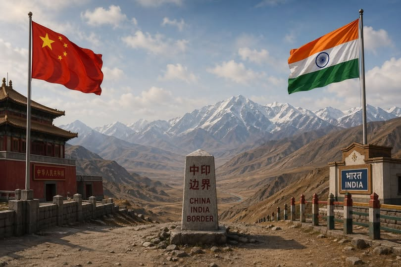
Modern Territorial Disputes: China & India as Expanding Powers
The Post-WWII International Order
The modern international system strongly discourages territorial expansion by force, which is why most nations have either shrunk (through decolonization or fragmentation) or stayed roughly the same size since 1945. Countries that have meaningfully grown their territory beyond their independence-era borders are rare — and China and India stand out as the primary examples among today’s rising “civilizational states.”
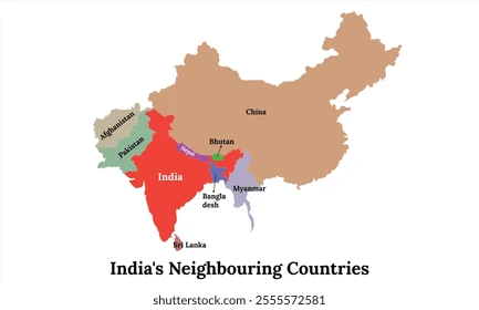
Both nations are also, not coincidentally, the world’s most prolific disputants over borders with their neighbors.
- China absorbed Tibet in 1950–51, and regained Hong Kong (1997) and Macau (1999)
- Fought a border war against Vietnam (1979) and had armed clashes with the Soviet Union along the Ussuri River (1969)
- Has shifted focus in recent decades from land to maritime expansion, constructing artificial islands and military installations in the South China Sea — facts on the ground now considered irreversible
- Disputes the Senkaku/Diaoyu Islands and surrounding EEZ with Japan, ongoing to this day
- Refuses to recognize borders drawn during the colonial era, including the McMahon Line (agreed between British India and Tibet in 1914), which defines the boundary of the entire state of Arunachal Pradesh — a territory China does not recognize
- Occupied Aksai Chin (formerly within British-administered Kashmir) in the early 1950s — disputed with India ever since
India pursued aggressive consolidation of its territory from independence onward, using both diplomacy and military force:
- Hyderabad (1948): The Muslim Nizam refused to join India; India launched “Operation Polo,” a military annexation. Hyderabad’s population at the time was roughly comparable to all of Burma
- Junagadh & Manavadar (1948): These princely states signed accession to Pakistan; India blockaded and militarily occupied them. Pakistan continued to claim Junagadh on official maps as recently as 2012
- Goa (1961): Seized from Portugal via “Operation Vijay” after 451 years of Portuguese rule — framed as decolonization, though India as a nation did not exist when Portugal took Goa
- Pondicherry (1954): Peacefully transferred from France ✓
- Sikkim (1975): A Buddhist monarchy under Indian “protection” was absorbed after a snap referendum — held while Indian troops were stationed there — reportedly showing 97.5% support for merger, a result the author finds implausible
- The Muslim-majority princely state of Jammu & Kashmir had a Hindu Dogra ruler who initially sought independence; under pressure from both India and Pakistan, he acceded to India, sparking the first Indo-Pakistani War (1947)
- Kashmir remains divided along a Line of Control, with no agreed final boundary — disputed by India, Pakistan, and China (over Aksai Chin)
- ———————-
- Both China and India have strategic interests involving Myanmar
- China seeks access to the Indian Ocean via the Irrawaddy corridor and Shan highlands
- India’s “Act East” policy seeks connectivity to Southeast Asia through Myanmar, and simultaneously aims to limit Chinese access to the Indian Ocean
- Despite this, Myanmar currently has no active territorial disputes with either neighbor — borders were resolved earlier and remain formally settled
- China exerts indirect influence through ethnic armed organizations (EAOs) along the border, but exercises no direct territorial control
- India has a heavy troop presence in Assam but no formal territorial claim against Myanmar; the main friction involves Manipuri nationalist sentiment over the Kabaw Valley
Both China and India are ascending civilizational powers with intense national pride. Neither has shown patience when territorial interests are at stake — both have demonstrated willingness to use force. As their global status rises, they may grow bolder still. Myanmar’s current border stability with both neighbors is fortunate, but not guaranteed.
The factual claims in this post are largely accurate and consistent with the historical record. The characterization of the Sikkim referendum and the skepticism around its results is a widely shared view among historians. The claim about Pakistan’s 2012 maps showing Junagadh is also documented.
Augustus.Linn
■ ဒုတိယကမ္ဘာစစ်လွန် မော်ဒန်နိုင်ငံတကာစနစ်မှာ ပိုင်နက်ဧရိယာ ပိုမို၍ ကျယ်ဝန်းလာသော နိုင်ငံဟူ၍ မရှိသလောက် ရှားပါတယ်။ အင်အားသုံး စစ်မက်ခင်း၍ နယ်မြေချဲ့ထွင်ခြင်းကို ခွင့်မပြုတာမို့ နိုင်ငံငယ်လေးများ အိပ်ကောင်းခြင်းအိပ်နိုင်ကြတယ်။ ကိုလိုနီနယ်များလွတ်လပ်ရေးရခြင်း , နှစ်ဘက်သဘောတူ ခွာပြဲကြခြင်း , ပြိုကွဲခြင်းတွေကြောင့် ကျုံ့သွားသော နိုင်ငံကသာ အရေအတွက်များတယ်။
သည်လိုပဲ အချုပ်အခြာအာဏာပိုင် ၂ နိုင်ငံအကြား အငြင်းပွားနေရသော မြေပိုင်နက် , ရေပိုင်နက်များသည် သဘောတူထားပြီးဖြစ်သည့် အသိအမှတ်ပြု နယ်ခြားစည်းနှင့်စာလျှင် နည်းပါးတယ်။ ရှိကြသည့်တိုင် ကျည်ပေါက်သော ပဋိပက္ခအဆင့်ထိ မရောက်စေပဲ စားပွဲဝိုင်းတွင်သာ ညှိဖို့ ကြိုးစားကြပါတယ်။
■ ကမ္ဘာစစ်အလွန် နယ်မြေများ စိတ်ပိုင်းပြီးနောက် ၇၅ နှစ်မျှသောကာလအတွင်း မူလပိုင်နက် , လွတ်လပ်ရေးရသည့်အချိန်က နယ်နိမိတ်ထက် သိသိသာသာ ပို၍တိုးလာသည်ဟူ၍ တရုတ် နှင့် အိန္ဒိယ , အင်ဒိုနီးရှားတို့သာ ရှိပါမယ်။ ယနေ့ ပါဝါတက်နေသော Civilizational နိုင်ငံများ ဖြစ်ကြခြင်းလည်း တူညီကြတယ်။
နယ်ခြားစည်းအရ အိမ်နီးချင်းများနှင့် အငြင်းအပွားဆုံး ဖြစ်နေရသည့် နိုင်ငံဆိုလျှင်လည်း အိန္ဒိယနှင့် တရုတ် ၂ နိုင်ငံကြီး ၂ နိုင်ငံကိုပဲ ထပ်၍ ညွှန်ပြရပါမယ်။ ၄င်းတို့ အကြားတွင်လည်း အငြိအစွန်း ဖြစ်နေကြသော အစိတ်အပိုင်း မြောက်များစွာ ရှိနေတယ်။ နယ်စပ်ပဋိပက္ခတွေလည်း ခပ်စိပ်စိပ် ဖြစ်ထားကြတယ်။
■ တရုတ်ပြည်သူ့ သမ္မတနိုင်ငံအနေဖြင့် တိဘက်ကို ၁၉၅၀-၅၁ မှာ သိမ်းယူခဲ့ပြီး ဟောင်ကောင်နှင့် မကာအိုတို့ကို ပြန်လည်လက်ခံရရှိခဲ့တယ်။ ဗီယက်နမ်ကို ကျူးကျော်စစ် ဝင်ခဲ့ဖူးသလို မိတ်ဖက်ဖြစ်သော ဆိုဗီယက်နှင့်ပင် နယ်ခြားပဋိပက္ခရှိခဲ့တယ်။
ယခုနောက်ပိုင်းနှစ်များတွင်တော့ မြေပိုင်နက်အစား ရေပိုက်နက် တိုးချဲ့ခြင်းကို အကြီးအကျယ်ပြုလာတယ်။ ရေပိုင်နက်ချင်းထိစပ်နေသော နိုင်ငံများအားလုံးနီးပါးနှင့် Territorial Disputes အငြင်းပွားမှု များရှိပြီး တောင်တရုတ်ပင်လယ်တွင် ကျွန်းတုများမြေဖို့ပြီး စစ်စခန်းများပင် အခိုင်အမာတည်ဆောက်ထားပြီးနေပြီမို့ ပြန်၍ဖယ်ပေးဖို့ရာ အကြောင်းမရှိတော့။ ဂျပန်နှင့်လည်း ရှင်ကာကူကျွန်းများနှင့် ဝန်းကျင်တဝိုက်ရှိ EEZ အတွက် အငြင်းပွားလျက် ရှိဆဲပင်။
■ မြန်မာတွင် တရုတ်နိုင်ငံ၏ နယ်နိမိတ်အရေးအရာများအကြောင်း လူသိများကြပေမယ့် အိန္ဒိယနှင့် ပတ်သတ်လျှင် အာရုံစိုက်မှု သိပ်မရှိကြသေးပါ။
အိန္ဒိယသည် လွတ်လပ်ရေးရသည်မှစ၍ ၄င်းတို့ဆန္ဒရှိထားသော နိုင်ငံတော်နယ်နိမိတ် တည်ဆောက် ပေါင်းစည်းနိုင်ရေးကို ပြင်းပြင်းထန်ထန် လုပ်ခဲ့တယ်။ စစ်ရေးနည်းလမ်းသုံးဖို့ လက်မတွန့်ပါ။
အဦးပထမ ဗြိတိသျှတို့ထံကနေ လွတ်လပ်ရေးယူဖို့အတွက် Option ရှိနေခဲ့သော ပဒေသရာဇ်ပြည်ထောင်များကို စည်းရုံး၍တမျိုး , ဖိအားပေး၍တဖုံ အိန္ဒိယနှင့် ပြည်ထောင်စုဖို့ သဘောတူစေခဲ့တယ်။ အိန္ဒိယနှင့် မပေါင်းလိုပဲ သီးခြားလွတ်လပ်ရေးယူခဲ့သည့် Hyderabad ကို အော်ပရေးရှင်းပိုလို စစ်ဆင်ရေးဖြင့် သိမ်းယူခဲ့တယ်။ Hyderabad ၏ လူဦးရေသည် ထိုစဥ်က ဗမာတနိုင်ငံလုံးနှင့် တူညီသလောက်ရှိနေတယ်။ ပါကစ္စတန်နှင့် ပူးပေါင်းရေးစာချုပ်ချုပ်ဆိုသော Junagadh နှင့် Manavadar ပြည်ထောင်များကိုလည်း ပိတ်ဆို့ တပ်စွဲပြီးသိမ်းပိုက်ခဲ့တယ်။ ၂၀၁၂ ထုတ် ပါကစ္စတန်နိုင်ငံထုတ် မြေပုံများစာအုပ်အထိ Junagadh ကို ပါကစ္စတန်အစိတ်အပိုင်းအဖြစ် ဆက်လက် Claim ထားဆဲပါ။
■ နောက်ဆုံးသော ဗြိတိသျှဘုရင်ခံချုပ် မောင့်ဘက်တန် အနေဖြင့် ကတိကဝတ်များ ရှိခဲ့သော်လည်း ပြောင်းလဲသွားသည့် ကမ္ဘာ့နိုင်ငံရေးကြောင့် ပဒေသရာဇ်တချို့၏ ကိုယ်ပိုင်ရွေးချယ်မှုကို ကာကွယ်ဖြည့်စည်းပေးနိုင်စွမ်းမရှိတော့ပါ။ တဖက်တွင်လည်း အိန္ဒိယတိုက်ငယ်ရှိ ပဒေသရာဇ်ပြည်ထောင်များ၏ ပြည်သူများကိုယ်တိုင်သည် တခုတည်းသော အိန္ဒိယနိုင်ငံသား အဖြစ်ပေါင်းစုဖို့ ပြည်သူ့ဆန္ဒပြင်းထန်တယ်။
ယင်းသည်ပင် Hyderabad နှင့် Junagadh တို့ကို သိမ်းပိုက်လိုက်သည့် အိန္ဒိယအစိုးရ၏ အကြောင်းပြချက် ဖြစ်လာတယ်။ ပဒေသရာဇ်များသည် မူဆလင်များဖြစ်သည်မို့ အိန္ဒိယနှင့် မပေါင်းလိုသော်လည်း ပြည်သူများက ဟိန္ဒူဘာသာဝင် အများစု ဖြစ်နေတယ်။
သို့သော် ပြည်သူအများက မူဆလင်အများစုဖြစ်သော ဂျာမူးနှင့်ကက်ရှမီးယား ပြည်ထောင်တွင်မူ ဟိန္ဒူများဖြစ်သည့် Dogra မင်းဆက်သည် လွတ်လပ်သောနိုင်ငံ ဖြစ်ဖို့ ကြိုးပမ်းခဲ့ကြသေးတယ်။ နှစ်ဖက်ဖိအားများကြောင့် မဖြစ်နိုင်သည့်အခါ အိန္ဒိယဘက်ကို ရွေးချယ်ခဲ့တာကြောင့် ပြည်တွင်းရေး မတည်မငြိမ်ဖြစ်သလို အိန္ဒိယနှင့် ပါကစ္စတန်တို့ စစ်မီးတောက်ကြတယ်။ ယနေ့တိုင် ထိမ်းချုပ်ထားနိုင်သည့် စည်းကနေ ခွဲခြားအုပ်ချုပ်နေပြီး နယ်နိမိတ် သဘောတူညီချက် မရပါ။
■ ဗြိတိသျှခေတ်က ကက်ရှမီးယားပြည်နယ်မြေအတွင်း ပါဝင်ခဲ့သော Aksai Chin ဒေသကိုမူ တရုတ်နိုင်ငံက ၁၉၅၀ ကျော်လွန်နှစ်များတွင် ဝင်ရောက်သိမ်းယူထားလို့ အိန္ဒိယနှင့် ယနေ့တိုင် အငြင်းပွားနေဆဲဖြစ်၏။ ကိုလိုနီခေတ်ကာလအတွင်း ဗြိတိိသျှတို့ တန်ခိုးထွားမှုဖြင့် ချုပ်ဆိုထားသော နယ်ခြားသဘောတူညီချက်များကို ယနေ့ ဘေဂျင်းက လက်မခံတော့။
သည်တွင် မြန်မာပြည်မြောက်ဖျား တဖက် အာရူနာချယ်ပရာဒေရှ့် ပြည်နယ်ကြီးတခုလုံး၏ တည်ရှိမှုကိုပါ တရုတ်နိုင်ငံက အသိအမှတ်မပြုပါ။ ၁၉၁၄ ခုနှစ်တွင် တိဘက်နှင့် ဗြိတိသျှအကြား သဘောတူခဲ့သော McMahon Line ၏ တရားဝင်မှုကို ဘေဂျင်းက လက်မခံတာကြောင့်ဖြစ်၏။
အထက်ပါပြည်နယ်ကြီးများတွင်သာမက Sikkim နယ်စပ်အပါအဝင် ညှိနှိုင်းမရသေးသည့် Disputed နယ်စပ်များ ဟိုတစသည်တစ ရှိနေသောကြောင့် နျူအင်အားကြီး ၂ နိုင်ငံအကြား မီးတကျည်ကျည် ဖြစ်လေ့ရှိတယ်။
■ အိန္ဒိယသည် ပွန်ဒီချယ်ရီကို ၁၉၅၄ ခုနှစ်တွင် ပြင်သစ်ထံကနေ ငြိမ်းငြိမ်းချမ်းချမ်း လွှဲပြောင်းရယူနိုင်ခဲ့ပေမယ့် ပေါ်တူဂီပိုင် ဂိုအာကိုမူ ၁၉၆၁ ခုနှစ်တွင် အော်ပရေးရှင်း ဗီဂျေးစစ်ဆင်ရေးဖြင့် သိမ်းပိုက်တယ်။ De-ကိုလိုနိုက်ဇေးရှင်း ဖြစ်ရပ်လို့ မြင်နိုင်သော်လည်း ပေါ်တူဂီတို့ ဂိုအာကို ရယူခဲ့စဥ်က အိန္ဒိယနိုင်ငံ မရှိသေးပါ။ ဂိုအာကို ပေါ်တူဂီတို့ ၄၅၁ နှစ်ကြာအုပ်ချုပ်ခဲ့ပြီး မြန်မာရာဇဝင်များတွင် ဂိုအာပိတ်စရည်းလို့ ရေးလေ့ရှိတယ်။
တိဘက်ဗုဒ္ဓဘာသာ ပဒေသရာဇ်နိုင်ငံဖြစ်ခဲ့သည့် Sikkim သည် အိန္ဒိယ၏ အစောင့်အရှောက်ခံ အဖြစ်နေလာရာကနေ ၁၉၇၅ တွင် အိန္ဒိယစစ်တပ်၏ တပ်စွဲထားစဥ် ရုတ်ခြည်း လူထုဆန္ဒခံယူပွဲလုပ်ပြီး နိုင်ငံအတွင်း သွတ်သွင်းလိုက်တယ်။ Sikkim လူထု ၉၇.၅ ရာနှုန်းက အိန္ဒိယနှင့် ပေါင်းစည်းလိုသည်ဟူသော ရလဒ်သည် ယုံကြည်စရာတော့ မကောင်းလှပါ။
■ တရုတ်နှင့် အိန္ဒိယ ၂ နိုင်ငံစလုံးသည် အနောက်တိုင်းနိုင်ငံများ ကိုလိုနီခေတ် လျှမ်းလျှမ်းတောက်စဥ်က ကိုယ်တိုင် နိမ့်ပါးသူများဖြစ်နေခဲ့ပေမယ့် အင်အားချိန်ခွင် ပြောင်းလာပြီးနောက် ငုပ်လျှိုးထားရသော ဇာတိ, ပုည, မာန်မာနများ ပြန်လည် ထကြွလာသည်မို့ နယ်မြေအရေးနှင့် ပတ်သတ်လျှင် မာကျောသော မူဝါဒများရှိတယ်။ နှိုင်းယှဥ်ရလျှင် နယူးဒေလီကပင် ပို၍ ရန်လိုတတ်တာ တွေ့ရမယ်။
ဤအတွက်ကတော့ တရုတ်သည် Power Projection အတွက် ပိုင်နက်စည်း ရှေ့တိုးလိုခြင်း ဖြစ်ရာ ကိုင်တွယ်ပုံသည် အလျင်မလိုပါ။ အိန္ဒိယအနေဖြင့်မူ နယ်မြေစုစည်းခြင်း ( Integration and Consolidation ) အဆင့်တွင်သာ ရှိသေးတယ်လို့ မြင်နိုင်တာကြောင့် မလုံခြုံမှု ပိုများတယ်။ စစ်ရေးလမ်းကြောင်းကို ရွေးချယ်ဖို့ ပို၍ လက်မြန်တယ်။
အရှေ့ပါကစ္စတန်ကို ဘဂ်လားဒေရှ့်ဖြစ်လာအောင် စစ်ရေးအရ စွက်ဖက်ဆောင်ရွက်နိုင်ခဲ့ခြင်းကတော့ အိန္ဒိယအပိုင်းတွင် စွမ်းဆောင်မှုအမှတ် အများဆုံးရတယ်။ ယင်းစစ်ပွဲတွင် အရေးနိမ့်ခဲ့မှုကြောင့် ပါကစ္စတန်၏ လုပ်နိုင်စွမ်းနှင့် ပထဝီအားသာချက် ထက်ဝက်နီးပါးကို လက်လွှတ်လိုက်ရတယ်။ အိန္ဒိယအရှေ့မြောက် ၇ ပြည်နယ်လည်း အတော်ပင် ကျောလုံသွားတယ်။
■ ရှမ်းရိုးမနှင့် ဧရာဝတီမြစ်ဝှမ်းကို ဖြတ်၍ တရုတ်တို့၏ အိန္ဒိယသမုဒ္ဒရာ ထွက်ပေါက် လိုလားခြင်းကို လူသိများတယ်။ သို့သော် အိန္ဒိယတွင်လည်း အရှေ့တောင်အာရှနှင့် ဆက်သွယ်လိုသော် အရှေ့မျှော်မူဝါဒ ရှိတယ်။ သည့်အပြင် တရုတ်တို့၏ ထွက်ပေါက်ကို ပိတ်လိုမယ်။ အိန္ဒိယသမုဒ္ဒရာအတွင်း ပြိုင်ဘက်မထားလိုပါ။
အိန္ဒိယသည် ၄င်းတို့ဘာသာ မူဝါဒများကို မနိုင်မနင်း တိုင်ပတ်၍ Power Projection လုပ်နိုင်စွမ်း မရှိလှသေးသော်လည်း ဗြိတိသျှခေတ် Raj မြေပုံကြီးကိုကိုင်၍ မြန်မာနှင့် တိဘက်သည် Bharat ( အိန္ဒိယ ) ၏ အစိတ်အပိုင်း ဖြစ်ခဲ့ဖူးကြောင်း ငြင်းနေသည့် အိန္ဒိယနွယ်ဖွား ပညာတတ် အမြောက်အများကိုပင် မကြာခဏ မြင်ရမယ်။
ကံကောင်းသည်ကား မြန်မာနှင့် အဆိုပါ အိမ်နီးချင်း နိုင်ငံကြီး ၂ နိုင်ငံအကြား အရေးအရာ ဖြစ်စရာ နယ်နိမိတ် အငြင်းပွားမှု မရှိနေပါ။ ရှေးရှေ့ကပင် ရှင်းလင်းခဲ့ပြီးပြီ။ တရုတ်နိုင်ငံအနေဖြင့် နယ်စပ်တလွှား တိုင်းရင်းသား ERO ထိမ်းချုပ်နယ်မြေများက တဆင့် သွယ်ဝိုက်၍ သြဇာညောင်းထားပေမယ့် တိုက်ရိုက်ပေါ်တင် ထိမ်းချုပ်သည်တော့ မရှိသေး။ အနောက်ဘက်တွင်လည်း အာသံရိုင်ဖယ်ကဲ့သို့ အိန္ဒိယတပ်များ လူပါးဝလွန်းတာရှိပေမယ့် ဒေလီနှင့် တိုက်ရိုက် နယ်မြေအငြင်းပွားစရာမရှိပါ။ ဒေသခံ မဏိပူရအမျိုးသားရေးသမားတို့၏ ကဘော်ချိိုင့်ဝှမ်းကို မျက်စောင်းထိုးမှုသာ ပြောစရာရှိ၏။
■ ယခု မရှိ , မဖြစ် ဟူသည် နောင်မဖြစ်လာဟု အာမခံခြင်းတော့မဟုတ်ပါ။ သိရမည်မှာ အိမ်နီးချင်း Civilizational နိုင်ငံကြီး ၂ ခုစလုံးသည် စူပါအဖြစ် အထက်သို့ တက်လူ ဖြစ်နေရာ ဇာတိမာန ဟုန်းဟုန်းထနေတယ်။ ၄င်းတို့၏ အမျိုးသားစီးပွား အကျိုးငှာ နယ်မြေအရေးများကို ဖြေရှင်းရာတွင်လည်း ခန္တီပါရမီ ဖြည့်သူများ မဟုတ်ပဲ လက်မြန်ခြေမြန်ဖြင့် အင်အားသုံးရန် ဝင်မလေးခဲ့ကြသလို နောင်တွင်လည်း နိုင်ငံတကာအနေအထားနှင့် ၄င်းတို့၏ Status ကို တည်မှီ၍ သာသာထိုးထိုး ရဲတင်းလာနိုင်စရာလည်း ရှိပါသေး၏။
၂၃ ဧပြီ ၂၀၂၆