Translated, edited and extended the post By Capt Aung Myin Moe
(Maritime Expert & Port State Control Expert for IOMOU)
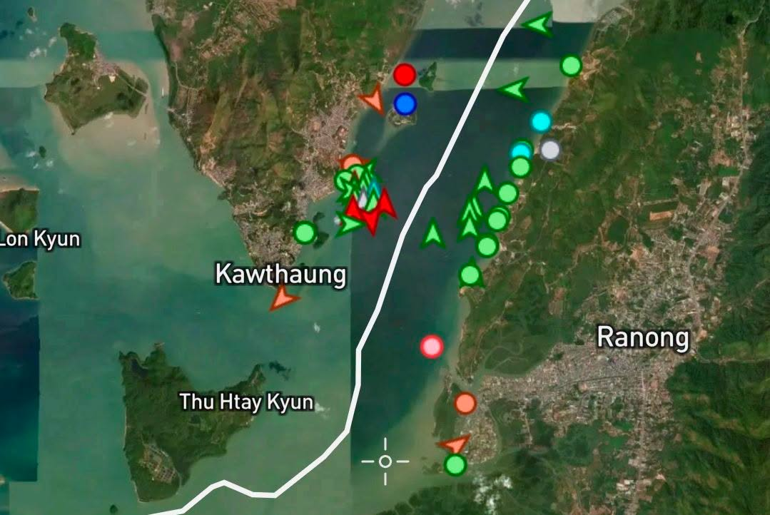
As Thailand’s Land Bridge Project moves forward—aiming to link Chumphon (Gulf of Thailand) and Ranong (Andaman Sea) via a 90 km road and rail logistics corridor—the Ranong port is set to become a primary Indian Ocean Gateway. Because Ranong directly borders Myanmar’s Tanintharyi Region (especially Kawthaung), vessel traffic right next to Myanmar’s territorial waters will surge exponentially.
While this brings massive economic potential, it simultaneously poses extreme maritime hazards, environmental threats, and sovereignty challenges. Myanmar must immediately enact legislative and logistical preparations to safeguard its interests.
Legal & Tactical Frameworks Required:
- Ratifying IMO Conventions (MARPOL Annex VI): Although a member of the International Maritime Organization (IMO), Myanmar has yet to ratify critical protocols like MARPOL Annex VI (Prevention of Air Pollution from Ships). Without this, global cargo vessels passing near the Myanmar coast will emit unregulated sulfur and smoke, heavily damaging our coastal air quality with zero legal recourse or right to penalize them.
- Oil Spill & Collision Liabilities: Increased traffic guarantees a higher risk of collisions and oil spills near the Myeik Archipelago and Kawthaung. While Myanmar benefits from the Civil Liability Convention (CLC) and FUND Convention for international tankers, it urgently needs strict domestic laws governing foreign and regional tugboats/barges (which are often exempt from standard international conventions) to claim millions in environmental damage from insurance companies.
- Establishing an Admiralty Court: Standard police stations and civil courts are poorly equipped to handle complex international maritime disputes. Myanmar must establish specialized Admiralty Courts with trained maritime judges and lawyers. This will ensure efficient arrest of defaulting ships (
Arrest of Ships) while avoiding undue delays that could conversely result in international counter-lawsuits against the state. - Environmental Sensitivity Mapping (ESI): Myanmar needs an active Environmental Sensitivity Index (ESI) Mapping system along the Tanintharyi coast. In the event of a spill, this map dictates where to immediately deploy oil booms to protect coral reefs, mangroves, and commercial fishing zones. It also acts as undeniable scientific evidence in court for damage claims.
- Expanding Port Limits & Designated Anchorages: Due to narrow Thai waters, ships waiting for berths at Ranong will inevitably encroach or anchor in Myanmar’s Territorial Sea and Contiguous Zone. Myanmar must legally extend the Port Limits of Kawthaung and Myeik further out into the ocean. By declaring protected natural bays near Kawthaung and Mawtaung as Designated Anchorage Areas, Myanmar can legally collect multi-million dollar Anchorage Fees, Port Dues, and Pilotage Fees in USD, while opening doors for private ship-supply and bunkering industries.
Part 2: Fact-Check & Contextual Updates
- Project Realities: Capt Aung Myin Moe’s assessment of Ranong’s proximity to Myanmar is geographically accurate. Ranong is separated from Kawthaung, Myanmar by the Pakchan River estuary.
- Timeline Update: Thailand’s current government continues to push the 1-trillion-baht ($30B+) Land Bridge project with public bidding and environmental/health assessments (EHIA) heavily under review. Though targeted to begin construction soon and partially open by 2030, localized friction and strict environmental audits mean Myanmar has a small, critical window of roughly 3 to 4 years to update its legislation before heavy vessel deployment begins.
Part 3: Expanded Blueprint for Commercial & Naval Expansion
To transition from “defending against threats” to “maximizing massive commercial profits,” Myanmar should implement the following multi-phase maritime and naval expansion plan:
1. Mega-Port Expansion & Advanced Logistics
- Deeper Deep-Sea Ports: Expand the existing Myeik or Dawei Deep Sea Port concepts. While Thailand’s Land Bridge targets feeder and medium-sized vessels to avoid the Malacca Strait, Myanmar can build specialized deep-draft terminals (>16 meters) capable of hosting massive Post-Panamax container vessels that Ranong’s shallow geographies cannot easily support, acting as a secondary transshipment hub.
- Luxury Cruise Hubs: The Myeik Archipelago is one of the world’s last pristine island ecosystems. Constructing dedicated cruise ship piers in Kawthaung with fast-tracked CIQ (Customs, Immigration, Quarantine) processing can capture wealthy eco-tourists shifting away from overcrowded Thai resorts.
2. High-Profit Maritime Services
- Free Port & Tax-Free Status: Establish a Special Economic Zone (SEZ) near Kawthaung with Free Port status. Offering duty-free fueling (bunkering), zero-tariff logistics warehousing, and tax-free ship-chandler (provisioning) services will incentivize international fleets to restock in Myanmar waters rather than Thailand.
- Ship Repair & Drydock Infrastructure: Build medium-to-large scale drydocks and maintenance yards. Ships waiting in the Andaman Sea frequently require emergency maintenance, hull cleaning, and machinery repairs.
3. Diplomatic & Military Regulations (Warships)
- Geopolitical Transit Laws: Under the United Nations Convention on the Law of the Sea (UNCLOS), foreign warships enjoy “Innocent Passage” through territorial seas but cannot conduct military exercises. Myanmar must draft clear regulatory codes requiring foreign warships to give formal prior notification or authorization requests before entering contiguous zones, protecting sovereign boundaries amid intense regional naval rivalries (e.g., US, India, China).
4. Modernizing and Extending the Myanmar Navy (Maritine Navy Forces)
To enforce the new laws, prevent illegal anchoring, and protect economic zones, the Myanmar Navy must be systematically upgraded:
- Procurement of OPVs (Offshore Patrol Vessels): Shift focus from heavy combat frigates to high-endurance, agile Offshore Patrol Vessels and fast attack craft equipped with advanced radar. These are ideal for policing the economic exclusive zone (EEZ), inspecting commercial ships, and conducting anti-piracy operations.
- Coast Guard Separation: Fully empower and fund the newly formed Myanmar Coast Guard to handle civil law enforcement, oil spill containment, and fisher protection, leaving the core Navy to focus strictly on national defense and strategic deterrence.
- Aviation & Satellite Surveillance: Integrate maritime patrol aircraft (MPA) and unmanned aerial vehicles (UAVs/Drones) stationed at regional naval bases (like Myeik and Coco Islands) to maintain 24/7 real-time monitoring of ship traffic without needing to burn ship fuel constantly.
To capture maximum economic advantages from surging maritime traffic, Myanmar must adopt a twin approach: establishing precise, airtight domestic legislation for revenue collection while creating competitive, zero-tariff commercial free zones modeled after the region’s top maritime hubs.
Part 1: Model Legislative Drafting Clauses for Anchorage Fees
To give the Ministry of Transport and Communications (or regional port authorities) a legal mechanism to penalize unauthorized entries and systematically monetize anchored ships, domestic maritime law can incorporate the following structural clauses:
📜 Clause 1: Declaration and Extension of Port Limits
“Extension of Jurisdiction over Contiguous Anchorage Areas:”
By order of the Minister, the designated maritime boundary of Kawthaung and Myeik Port Authorities shall extend outward to include all territorial waters and natural bays spanning to the outermost limit of the Contiguous Zone ($24\text{ nautical miles}$ from the baseline). Any vessel entering this zone for purposes other than continuous, uninterrupted transit (‘Innocent Passage’) shall be legally deemed within the Port Limits and subject to local port regulations and dues.”
📜 Clause 2: Mandatory Use of Designated Anchorages
“Compulsory Anchorage Declaration:”
No foreign commercial vessel, tug, barge, or feeder ship exceeding $500\text{ Gross Tonnage (GT)}$ waiting for berthing, transshipment, or logistics services in adjacent foreign ports (including the Ranong Land Bridge) shall anchor, drop hook, or remain stationary within Myanmar’s Port Limits except inside a designated, geographically coordinate-mapped Designated Anchorage Area. Failure to comply shall result in an immediate administrative fine of $50,000\text{ USD}$ and immediate vessel detention under the
Arrest of Shipsprotocol.”
📜 Clause 3: Tiered Structuring of Port & Anchorage Fees
“Assessment of Anchorage and Overstay Fees:”
All vessels utilizing a Designated Anchorage Area shall be charged an Anchorage Fee calculated per $100\text{ GT}$ (or part thereof) per 24-hour block, structured progressively to incentivize swift turnover or active commercial operations:
- Category A (Bunkering, Provisioning, or Ship Supply in Myanmar): Base rate of $4.00\text{ USD}$ per $100\text{ GT}$ per day for the first 4 days.
- Category B (Idle Waiting / Lay-up without local commercial activity): Premium rate of $12.50\text{ USD}$ per $100\text{ GT}$ per day for days 1–10. An escalated overstay tariff of $33.50\text{ USD}$ per $100\text{ GT}$ per day shall apply automatically from the 11th day onward.
Part 2: How Regional Hubs Structure Maritime Tax-Free Zones
To convince shipping lines to stop in Myanmar waters rather than moving directly to Thailand, Myanmar can study how Singapore and Malaysia (specifically Malacca/Port Klang) structure their maritime regimes.
🇸🇬 1. The Singapore Model: Concessionary Tariffs & Strategic Rebates
The Maritime and Port Authority of Singapore (MPA) doesn’t just rely on standard taxes; they use smart tariff structuring to reward specific behaviors:
- Concessionary Dues for Owners’ Matters: Singapore heavily discounts port dues if a ship enters only for “owners’ matters” (e.g., taking on bunker fuel, changing crew, or loading supplies) rather than loading cargo. For example, a ship doing cargo work might pay high rates, but a ship taking on fuel or repairs pays a highly discounted base rate for its first 24–48 hours.
- The Approved International Shipping Enterprise (AIS) Scheme: Shipping companies that choose Singapore as their operational hub enjoy 100% tax exemptions on qualified shipping income for up to 10 years, encouraging global maritime firms to register locally.
🇲🇾 2. The Malaysia Model: Free Commercial (FCZ) vs. Free Industrial (FIZ) Zones
Malaysia uses the Free Zones Act 1990 to split free-trade capabilities into two specialized formats. This is a brilliant blueprint for Myanmar’s Tanintharyi coast:
| Feature | Free Commercial Zone (FCZ)(e.g., Port Klang / Malacca) | Free Industrial Zone (FIZ)(e.g., Shipyards/Manufacturing) |
| Primary Purpose | Trading, break-bulk cargo handling, sorting, repacking, and global transit. | Value-added manufacturing, ship assembly, and heavy engineering/repair. |
| Tax Relief | 100% exemption from customs duties, sales tax, and service tax on goods entering for re-export. | Exempt from import duties on raw materials, machinery, and shipyard equipment. |
| Customs Regime | Deemed “outside the principal customs area”—goods move freely without paperwork until they cross inland. | Strict customs monitoring; requires a high portion of the output to be exported out of the country. |
Part 3: Actionable Roadmap for Myanmar
If Myanmar wishes to replicate these successes near Kawthaung/Myeik, the immediate blueprint requires:
- Drafting an “Andaman Free Port Act”: Declare a perimeter around Kawthaung as an FCZ. Allow international ship chandlers (supply companies) to import fresh food, spare parts, and engine oils with zero tariffs, meaning they can sell them to anchored ships cheaper than Thai competitors.
- Licensed Bunkering Framework: Create strict domestic licensing for private fuel tankers. By offering bonded, tax-deferred fuel storage, Myanmar can provide low-cost bunkering services to ships waiting in the Andaman Sea.
- Shipyard “Pioneer Status”: Offer foreign shipyard operators (e.g., from Japan, China, or Singapore) a 5-to-10 year tax holiday (“Pioneer Status”) if they construct drydocks and ship-repair slips along the deep-draft channels of the Tanintharyi coast.
Exploiting Thailand’s massive logistical ambitions—whether via their Ranong Land Bridge or their established Eastern Seaboard—requires Myanmar to move past simple border checkpoints and aggressively build out its own regional transit arcs.
Historically, projects like the Dawei Deep Sea Port Road Link (a planned 138 km road corridor connecting Dawei to Thailand’s Kanchanaburi border at Ban Phu Nam Ron) were intended to create an “Economic Bridge” between the Andaman Sea and the Gulf of Thailand.
To maximize the benefits of these connection points, Myanmar can implement the following strategic recommendations across local road, rail, and policy infrastructure:
1. Capitalizing on the “Reverse Leakage” of the Thai Land Bridge
The Thai Land Bridge relies heavily on a 90 km highway/rail link between Chumphon and Ranong. Because Ranong shares the narrow Pakchan River estuary with Kawthaung, Myanmar can practically tap directly into Thailand’s multi-billion dollar investment.
- The Kawthaung–Ranong Fixed Link (Bridge/Ferry Hub): Rather than letting Ranong monopolize the cargo, Myanmar should establish high-capacity, roll-on/roll-off (RoRo) ferry terminals or propose a joint-venture bridge across the Pakchan estuary.
- The Bunkering Hook: If international containers are offloaded at Ranong, Myanmar can pull those same trucks into a tax-free processing zone just across the border by offering cheaper, expedited secondary logistics services.
2. Reviving the Dawei–Kanchanaburi Highway & Rail Corridor
The Dawei Road Link is already conceptualized as the final western piece of the Greater Mekong Subregion (GMS) Southern Economic Corridor.
- Upgrade to an “Intermodal” Corridor: The initial blueprint included upgrading a 2-lane gravel road to an asphalt highway backed by Thai development loans (NEDA). Myanmar should renegotiate these frameworks to demand a dual-gauge rail link running alongside the highway.
- The Land-Bridge Competitor: While Thailand’s Land Bridge targets medium feeder ships, a completed Dawei deep-sea port connected to Kanchanaburi via rail creates a direct 8-hour overland shortcut to Bangkok and the South China Sea. Myanmar can route ultra-large container vessels (which cannot dock in Ranong due to shallower drafts) through Dawei, beating Thailand at its own game.
3. Implementing GMS Cross-Border Transport Agreements (CBTA)
Infrastructure is useless without modern regulatory alignment. Thailand and other Mekong nations have signed numerous protocols of the GMS CBTA, which streamlines customs procedures.
- Single-Window Inspections: Myanmar must establish “Single-Stop Inspection” systems at the Kanchanaburi/Nam Phu Ron and Mae Sot/Myawaddy borders. If a truck can clear both Myanmar and Thai customs in a single joint facility, transit times drop significantly.
- Bonded Trucking Laws: Enact clear laws allowing “sealed” international container trucks to pass through Myanmar’s local roads without paying standard domestic tariffs, provided they are transferring cargo between the ports and the Thai border. Myanmar can monetize this purely via flat Transit Tolls rather than complex duties.
4. Securing the ASEAN Highways (AH112 and AH123)
The Economic Research Institute for ASEAN and East Asia notes that key segments like AH112 (Lahnya to Khlong Loy) and AH123 (Dawei to Phu Nam Ron) have historically faced delays.
- Build-Operate-Transfer (BOT) Concessions: To avoid straining the national budget, Myanmar should lease out the construction and maintenance of these specific highway corridors to private international consortiums via BOT schemes. The private firms build the roads, and Myanmar splits the automated electronic toll revenues collected from the surging Thai-bound freight traffic.
By strategically placing specialized dry ports, customs hubs, and manufacturing zones right at the mouths of these road and rail links, Myanmar stops being just a bystander to Thailand’s logistics boom and instead becomes an essential partner that clips a coupon on every container moving through the region.
Aung Myin Moe
အမျိုးသားအကျိုးစီးပွား – Capt အောင်မြင်မိုး
ထိုင်း Land Bridge နှင့် မလွဲမသွေရင်ဆိုင်ရမည့် မြန်မာ့ရေကြောင်းအန္တရာယ်နှင့် ဥပဒေကြောင်းအရ ကြိုတင်ပြင်ဆင်မှုများ
ထိုင်းနိုင်ငံ၏ မဟာဗျူဟာမြောက် ကုန်းတွင်းတံတားစီမံကိန်း (Land Bridge Project) စတင်ပြီး ကန်ချာနာဘူရီမှတစ်ဆင့် ကရင်ပြည်နယ်၊ မွန်ပြည်နယ်နှင့် တနင်္သာရီတိုင်း ကမ်းရိုးတန်းတစ်လျှောက်နှင့် ထိစပ်နေသော ရနောင်း (Ranong) ဆိပ်ကမ်းသည် အိန္ဒိယသမုဒ္ဒရာ၏ အဓိကထွက်ပေါက် (India Ocean Gateway) ဖြစ်လာပါက မြန်မာ့ရေပိုင်နက်နှင့် ကပ်လျက်တွင် သင်္ဘော အသွားအလာ အဆမတန် ထူထပ်လာတော့မည် ဖြစ်သည်။
ဤအခြေအနေသည် မြန်မာနိုင်ငံအတွက် စီးပွားရေးအခွင့်အလမ်းအချို့ ရှိနိုင်သော်လည်း ရေကြောင်းအန္တရာယ်၊ သဘာဝပတ်ဝန်းကျင်ပျက်စီးမှုနှင့် အချုပ်
အခြာအာဏာဆိုင်ရာ စိန်ခေါ်မှုများအကြီးအကျယ်
ရှိလာမည် ဖြစ်သည်။ဒီအတွက် မိမိတို့နိုင်ငံ၏ ရေကြောင်းအကျိုးစီးပွားကို ကာကွယ်ရန် ဥပဒေကြောင်းအရခုချိန်မှာကြိုတင်ပြင်ဆင်ရပါမည်။ နောက်ကျနေတယ်လို့တောင်သုံးသပ်နိုင်ပါတယ်။ ဘာကြောင့်လဲဆိုတော့ ဥပေဒ တွေကခုမှစလုပ်မယ်ဆိုလျင်တောင် နောက် ၃ / ၄နှစ်မှ အတည်ပြုနိုင်မှာဖြစ်လို့ဖြစ်ပါတယ်။
ဥပမာအနေနဲ့ကျွန်တော် သုံးသပ်ပြပါမယ်…
 နိုင်ငံတကာကွန်ဗင်းရှင်းများ လက်မှတ်ရေးထိုးခြင်းနှင့် MARPOL Annex VI ၏ အရေးပါမှု
မြန်မာနိုင်ငံသည် အပြည်ပြည်ဆိုင်ရာ ရေကြောင်းအဖွဲ့ချုပ် (IMO) ၏ အဖွဲ့ဝင်ဖြစ်သော်လည်း ပင်လယ်ရေထုညစ်ညမ်းမှု ကာကွယ်ရေးကွန်ဗင်းရှင်း (MARPOL) ၏ အချို့သော အရေးကြီးသည့် နောက်ဆက်တွဲ (Annex) များကို ယနေ့တိုင် လက်မှတ်ရေးထိုးခြင်း (Ratify) မပြုရသေးပါ။ ၎င်းတို့အနက် MARPOL Annex VI (သင်္ဘောများမှ လေထုညစ်ညမ်းမှု ကာကွယ်ရေး)သည် အရေးအကြီးဆုံး ဖြစ်လာသည်။ ရနောင်းသို့ ဝင်ထွက်မည့် ကုန်တင်သင်္ဘောကြီးများသည် မြန်မာ့ကမ်းရိုးတန်းနှင့် အနီးကပ်ဆုံး ဖြတ်သန်းရမည်ဖြစ်သည်။ MARPOL Annex VI ကို လက်မှတ်ရေးထိုးပြီး ပြည်တွင်းဥပဒေအဖြစ် ပြဌာန်းထားလျှင် မြန်မာ့ရေပိုင်နက်အတွင်း ဖြတ်သန်းသော သင်္ဘောများ၏ ဆာလဖာ (Sulfur) ထုတ်လွှတ်မှုနှင့် မီးခိုးငွေ့ညစ်ညမ်းမှုများကို မြန်မာနိုင်ငံ အနေဖြင့် စစ်ဆေးခွင့်၊ အရေးယူပိုင်ခွင့် ရရှိမည်ဖြစ်သည်။ အကယ်၍ လက်မှတ်မထိုးထားပါက မိမိတို့ကမ်းရိုးတန်းတွင် လေထုညစ်ညမ်းမှုဒဏ်ကို ခံရုံကလွဲ၍ ဥပဒေအရ မည်သို့မျှ အရေးယူနိုင်မည်မဟုတ်ပါ။
ရေနံယိုဖိတ်မှုနှင့် သင်္ဘောချင်းတိုက်မိခြင်းဆိုင်ရာ နောက်ဆက်တွဲပြဿနာများ (Consequences)
သင်္ဘောအသွားအလာ များပြားလာသည်နှင့်အမျှ ရေနံယိုဖိတ်မှု (Oil Spill)နှင့်သင်္ဘောချင်းတိုက်မိမှု (Collision)များသည် မြန်မာ့ရေပိုင်နက်နှင့် သီးသန့်စီးပွားရေးဇုန် (EEZ) အတွင်း မလွဲမသွေ ဖြစ်ပွားလာနိုင်သည်။
ပတ်ဝန်းကျင်ထိခိုက်မှုနှင့် အရေးယူခွင့် မှာ ထိုင်းဘက်သို့အသွား သင်္ဘောချင်းတိုက်မိ၍ဖြစ်စေ၊ ရေနံတင်သင်္ဘော သောင်တင်၍ဖြစ်စေ ရေနံများ မြန်မာ့ရေပိုင်နက် (အထူးသဖြင့် မြိတ်ကျွန်းစုနှင့် ကော့သောင်းကမ်းရိုးတန်း) ဘက်သို့ လွင့်ပါးလာပါက သဘာဝပတ်ဝန်းကျင်နှင့် ရေလုပ်ငန်းကိုအကြီးအကျယ်ထိခိုက်မှုဖြစ်စေနိုင်သည်။
မြန်မာနိုင်ငံအနေဖြင့် ရေနံညစ်ညမ်းမှုအတွက် အရပ်ဘက်တာဝန်ရှိမှုဆိုင်ရာ ကွန်ဗင်းရှင်း(CLC Convention) နှင့် ရန်ပုံငွေဆိုင်ရာ ကွန်ဗင်းရှင်း (FUND Convention) တို့တွင်သက်ေရာက်မှုရှိသော်လည်း၊ နိုင်ငံခြား(ပြည်တွင်း) မှတ်ပုံတင် နှင့် တွန်းဆွဲ သဘော်များအတွက် သီးခြားတာဝန်ယူမှူတာဝန်ခံမှုအပိုင်းပတွက်သီးခြားဥပေဒသက်ေရာက်မှုအရေးကြီးပါတယ်။ ဥပမာ စင်ကာပူ မှ မလေးမှတ်ပုံတင်ပြည်တွင်းတွန်းဆွဲ သဘော်များအတွက်သီးခြားအရေးယူနိုင်မှုအကာအသွယ်ရှိသည့်ပုံစံဖြစ်ပါတယ်။ (ပြည်တွင်းသဘော်များမှာ Convention မှကင်းလွတ်နေသဖြင့်)သို့မှသာ အကျိုးသက်ရောက်မှု (Consequence) အဖြစ် ပျက်စီးသွားသော ကမ်းခြေများ၊ ရေလုပ်ငန်းများနှင့် သဘာဝပတ်ဝန်းကျင် ပြန်လည်ကုစားရေးအတွက် အပြစ်ရှိသော သင်္ဘောလိုင်း/အာမခံကုမ္ပဏီထံမှ ဒေါ်လာသန်းပေါင်းများစွာ တရားဝင် လျော်ကြေးတောင်းခံခွင့် (Claim) ရရှိမည်ဖြစ်သည်။
နောက်တစ်ချက်အရေးအကြီးဆုံးမှာရေကြောင်းဆိုင်ရာ စီရင်ပိုင်ခွင့်နှင့် တရားရုံးလိုအပ်ချက်များ (Admiralty Jurisdiction) ဖြစ်ပါတယ်။
လက်ရှိ မြန်မာနိုင်ငံ၏ ရေကြောင်းဥပဒေစနစ်နှင့် တရားရုံးများသည် နိုင်ငံတကာအဆင့် ရေကြောင်းအငြင်းပွားမှုများနှင့် ပြစ်မှုများကို ကိုင်တွယ်ရန် အားနည်းချက်များ ရှိနေသေးသည်။ ရေကြောင်းဘက်ဆိုင်ရာပမှူအခင်းများကို သာမန်ရဲစခန်းများမှတဆင့်အမှူဖွင့်အရေးယူပုံစံပြုလုပ်ရန်သင့်လျော် လျော်ကန်မှုမရှိသဖြင့်နိုင်ငံတကာတွင်သီးခြား တရားစီရင်မှုစနစ်ထားရှိကြပါတယ်။
ရေကြောင်းတရားရုံး (Admiralty Court) သီးသန့်လိုအပ်ချက်မှာ သင်္ဘောချင်းတိုက်မိမှု၊ ရေထုညစ်ညမ်းမှု သို့မဟုတ် မြန်မာ့ရေပိုင်နက်အတွင်း တရားမဝင် ကျောက်ချရပ်နားမှုများ ဖြစ်ပွားပါက အမှုများကို အထူးပြုကိုင်တွယ်နိုင်မည့် “Admiralty Court” (သို့မဟုတ်) ရေကြောင်းအထူးတရားရုံးများကို သတ်မှတ်ပြဌာန်းထားရမည်။
နိုင်ငံတကာ ရေကြောင်းဥပဒေ (Maritime Law) ကို ကျွမ်းကျင်သော တရားသူကြီးများနှင့် ရှေ့နေများကို ကြိုတင်မွေးထုတ်ထားရမည်ဖြစ်ပြီး၊ ပြစ်မှုကျူးလွန်သော သင်္ဘောများကို ဥပဒေအရ ချက်ချင်း ဖမ်းဆီးထိန်းသိမ်းခွင့် (Arrest of Ships)ပြဌာန်းချက်များကို ပိုမိုထိရောက်အောင် အဆင့်မြှင့်တင်ထားရမည်။
ရေကြောင်းဘက်ဆိုင် အရေးယူစီရင်မှုများသည်အလျော်အစားတတ်ဖိုးကြီးလှသလို Un due delay Un due Arrest ဖြစ်ပါကလဲနိုင်ငံမှပြန်လည်တရားစွဲဆိုခံရနိုင်သဖြင့် အထူးအလေးထားရပါတယ်။
Sensitivity Mapping (ထိခိုက်လွယ်မှု မြေပုံစနစ်) ပြင်ဆင်ထားမှု
ရေနံယိုဖိတ်မှု သို့မဟုတ် ရေကြောင်းမတော်တဆမှုတစ်ခု ဖြစ်လာပါက မည်သည့်နေရာကို အရင်ဦးစားပေးကာကွယ်ရမည်နည်း ဟူသော Environmental Sensitivity Index (ESI) Mapping မြေပုံများ မြန်မာ့ကမ်းရိုးတန်း (အထူးသဖြင့် တနင်္သာရီကမ်းရိုးတန်း) အတွက် ရှိနေဖို့ လိုအပ်သည်။
မြိတ်ကျွန်းစုကဲ့သို့ သန္တာကျောက်တန်းများ၊ လမုတောများနှင့် ရေငန်ပုစွန်/ငါးဖမ်းကွက်များရှိရာ ဒေသများကို “အလွန်ထိခိုက်လွယ်သောဇုန်” အဖြစ် မြေပုံရေးဆွဲထားရမည်။
ဤမြေပုံရှိမှသာ မတော်တဆမှုဖြစ်လျှင် ကယ်ဆယ်ရေးနှင့် ရေနံဝိုင်းတားဆီးရေးလုပ်ငန်း (Oil Boom များချခြင်း) ကို စနစ်တကျ လုပ်ဆောင်နိုင်ပြီး၊ တရားရုံးတွင် လျော်ကြေးတောင်းခံရာ၌လည်း ခိုင်မာသော အထောက်အထားအဖြစ် အသုံးပြုနိုင်သည်။
ရေပိုင်နက်အတွင်း ပြည်တွင်းဥပဒေများ သက်ရောက်စေမှုနှင့် ဆိပ်ကမ်းနယ်နိမိတ် (Port Limits) တိုးချဲ့မှု
ရနောင်းဆိပ်ကမ်းသို့ တန်းစီစောင့်ဆိုင်းမည့် သင်္ဘောများသည် ထိုင်းရေပိုင်နက် ကျဉ်းမြောင်းမှုကြောင့် မြန်မာ့ရေပိုင်နက် (Territorial Sea) နှင့် ထိစပ်ဇုန် (Contiguous Zone) များထဲအထိ ကျူးကျော်ဝင်ရောက် ကျောက်ချခြင်း၊ သန့်ရှင်းရေးလုပ်ခြင်းများ ပြုလုပ်လာနိုင်သည်။
မြန်မာ့ရေပိုင်နက်အတွင်း ဖြတ်သန်းခွင့် (Innocent Passage) ကို ခွင့်ပြုရမည်ဖြစ်သော်လည်း၊ မိမိနိုင်ငံ၏ လုံခြုံရေး၊ အကောက်ခွန်၊ လူဝင်မှုကြီးကြပ်ရေးနှင့် သဘာဝပတ်ဝန်းကျင်ဥပဒေများကို ချိုးဖောက်ပါက အချုပ်အခြာအာဏာအရ အပြည့်အဝ အရေးယူပိုင်ခွင့်ရှိကြောင်း ပြည်တွင်းဥပဒေများတွင် တိတိလင်းလင်း မွမ်းမံထားရမည်။
ကော့သောင်းနှင့် မြိတ်ဆိပ်ကမ်းတို့၏ ဆိပ်ကမ်းနယ်နိမိတ် (Port Limits) ကို ဥပဒေကြောင်းအရ ပင်လယ်ပြင်ဘက်သို့ တိုးချဲ့သတ်မှတ်ရမည်။ ထိုသို့ တိုးချဲ့မှသာ မိမိတို့ ဆိပ်ကမ်းဧရိယာအတွင်း ရောက်ရှိလာသော သင်္ဘောများကို ထိန်းချုပ်ကွပ်ကဲခွင့် ရရှိမည်ဖြစ်သည်။
ကျောက်ကွင်း (Anchorage Areas) များကို ဆိပ်ကမ်းနယ်နိမိတ်အဖြစ် သတ်မှတ်ပြီး အခွန်အခ ရရှိစေရန် ပြင်ဆင်မှု
ရနောင်းဆိပ်ကမ်းသို့ ဝင်မည့် သင်္ဘောအုပ်စုကြီးသည် ဆိပ်ကမ်းအတွင်း နေရာမရမချင်း ကော့သောင်းနှင့် မောရတောင် ကမ်းရိုးတန်းအနီးရှိ သဘာဝအကာအကွယ်ရသော မြန်မာ့ပင်လယ်အော်များတွင် ကျောက်ချရပ်နားရန် (Anchorage) အခွင့်အလမ်း ရှာကြလိမ့်မည်။ ဤသည်မှာ မြန်မာနိုင်ငံအတွက် အခွန်ရနိုင်မည့် ရွှေကွက်ပဲလို့ကျွန်တော်သုံးသပ်ပါတယ်။
ဥပဒေအရ ကြိုတင်ပြင်ဆင်မှုအနေဖြင့်မြန်မာ့ရေပိုင်နက်အတွင်း သင့်တော်သော နေရာများကို “တရားဝင် ကျောက်ကွင်းဧရိယာများ” (Designated Anchorage Areas)အဖြစ် ဥပဒေအရ ကြေညာပြီး ၎င်းတို့ကို ဆိပ်ကမ်းနယ်နိမိတ် (Port Limits) ထဲသို့ ထည့်သွင်းထားရပါမယ်.ထိုသို့ သတ်မှတ်ပြီးပါက ရပ်နားသော သင်္ဘောများထံမှကျောက်ချမှုအတွက်အခွန်အခ (Anchorage Fees)၊ ဆိပ်ကမ်းဝင်ကြေး (Port Dues) နှင့် ရေကြောင်းပြခိုင် (Pilotage Fees) များကို ဥပဒေအကာအကွယ်ဖြင့် ဒေါ်လာငွေ တရားဝင် ကောက်ခံနိုင်သည်။ ထို့ပြင် အဆိုပါသင်္ဘောများထံ ရိက္ခာ၊ ရေချိုနှင့် လောင်စာဆီ ပြန်လည်ရောင်းချသည့် စီးပွားရေး (Bunkering & Ship Supply) လုပ်ငန်းများကိုလည်း ပြည်တွင်းဥပဒေနှင့်အညီ ပုဂ္ဂလိကကဏ္ဍသို့ ခွင့်ပြုပေးပြီး အခွန်တိုးမြှင့်နိုင်ပါတယ်။
ထိုင်းနိုင်ငံ၏ Land Bridge Project သည် ရနောင်းကို အိန္ဒိယသမုဒ္ဒရာ၏ တံခါးပေါက်ဖြစ်စေသကဲ့သို့၊ မြန်မာ့ပင်လယ်ပြင်ကိုလည်း အန္တရာယ်နှင့် အခွင့်အလမ်းများ ပြည့်နှက်နေသည့် “ဖြတ်သန်းရာလမ်းမကြီး” ဖြစ်လာစေနိုင်ပါတယ်။ မြန်မာနိုင်ငံအနေဖြင့် ဘေးထိုင်နံသာဖျန်းနေ၍မရဘဲ နိုင်ငံတကာကွန်ဗင်းရှင်းများ လက်မှတ်ထိုးခြင်း၊ ပြည်တွင်းရေကြောင်းဥပဒေများ အဆင့်မြှင့်တင်ခြင်း၊ ရေကြောင်းတရားရုံးများ တည်ထောင်ခြင်းနှင့် ကျောက်ကွင်းဧရိယာများ သတ်မှတ်၍ အခွန်ကောက်ခံရန် ဥပဒေကြောင်းအရ ကြိုတင်ပြင်ဆင်ခြင်းတို့ကို ယခုကတည်းက အမြန်ဆုံး အကောင်အထည်ဖော်မှသာ မိမိနိုင်ငံ၏ ရေကြောင်းအကျိုးစီးပွားနှင့် သဘာဝပတ်ဝန်းကျင်ကို အပြည့်အဝ ကာကွယ်နိုင်မည် ဖြစ်ပါကြောင်း တိုက်တွန်း ရေးသားလိုက်ရပါသည်။
Capt Aung Myin Moe
ရေကြောင်းဘက်ဆိုင်ရာကျွမ်းကျင်သူ
PSC Expert for IOMOU