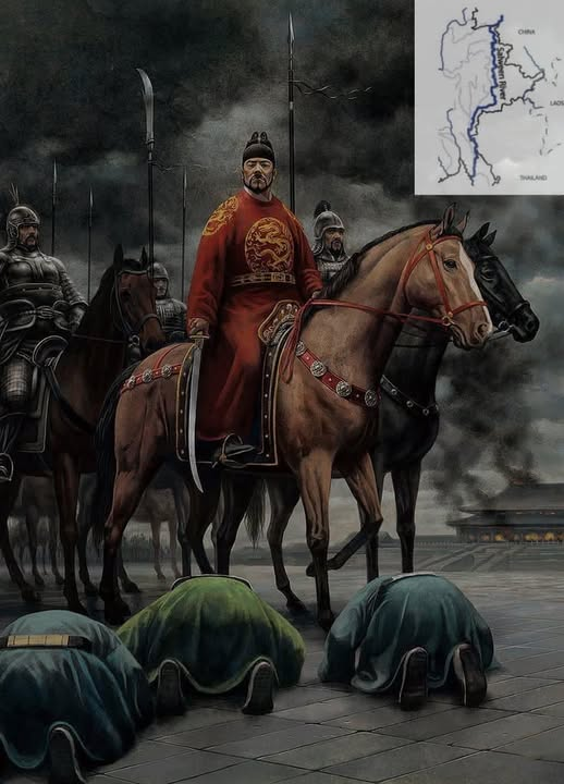
China’s Old Designs on Myanmar
For more than 130 years, China has tried to redraw Myanmar’s map. As far back as the Kengtung Incident of 1890 and the London Agreements of 1891–1894, Beijing pressed for vast swathes of our land: east of the Shweli, east of the Salween, the Kokang, Wa, Mong La regions, and even the whole of Eastern Shan State between the Salween and Mekong rivers.
These were not small claims. China wanted nothing less than half of Shan hills—territories that had for centuries looked westward to Mandalay, not eastward to Yunnan.
How Britain Blocked the Grab
At first, some in London thought about conceding Kengtung to China. It was mountainous, poor in revenue, and far from Rangoon. But key colonial officials like Chief Commissioner Crosthwaite and Shan administrator J.G. Scott pushed back. They argued that Kengtung had long paid tribute to the Burmese kings and was crucial for Britain’s prestige.
In 1891, Scott marched into Kengtung with a small escort, met the Sawbwa face-to-face, and signed a treaty of protection. This one act ensured Kengtung remained inside Burma. If not, today’s map of Myanmar might be very different.
The London talks (1891–1894) dragged on for three years. China’s envoys—including Ambassador Tseng and adviser Sir Halliday Macartney—insisted on grabbing land east of the Salween and Mekong. Britain’s answer was clear: China had not exercised real control there for a century, no Chinese lived or traded in the Mekong valley, and the Kachin duwas traded only with Burmese towns like Bhamo.
Frustrated, China even proposed turning the entire Kachin Hills into a “buffer land.” The British refused. In the end, the border was fixed along the mountain ridges, not the rivers. The 1891–1894 London Agreement locked in Myanmar’s eastern frontier much as we know it today.
China’s Old Greed, Today’s Reality
Why did China want these lands then? The answer is obvious when we look at what China is doing right now in those same regions:
- In Kachin and Bhamo: Chinese roads, trade corridors, and smuggling routes.
- Along the Mekong and Shweli: Logging, hydropower dams, and mining projects.
- In Kokang, Wa, Mong La, and eastern Kengtung: China dominates the economy, controls markets, and builds “special regions” that function like its own protectorates.
What China failed to seize in the 1890s through diplomacy, it now takes through business deals, resource extraction, and proxy armies.
A Warning From History
If the British had given way in 1890, Kengtung, Kokang, and Wa might already be part of Yunnan today. We must not forget that China’s appetite for Myanmar’s land is old, persistent, and dangerous.
As the saying goes: “History lights the path of future politics.”
Myanmar must wake up: China’s claws have been reaching for our borderlands for more than a century. What was once an imperial dream is now a creeping reality on our soil.
Call to Unity
In the face of this long shadow of Chinese ambition, the people of Myanmar—Bamar, Shan, Kachin, Karen, Rakhine, Mon, Chin, and all religious communities including Buddhists, Muslims, Christians, and Hindus—must stand together. Only through unity, dignity, and vigilance can we defend our sovereignty and ensure that no foreign power, however large, can decide our destiny.
— Credit: M. Kwan La (translated, verified, and reshaped for MMNN)
Min Gyi
nSterosdoph8gu pmtme11et1 b94i43m52h,29121a175mah6ea1001g1Sr ·
လွန်ခဲ့တဲ့ နှစ်ပေါင်း (၁၃၀) ကတည်းက မြန်မာပြည်
တခြမ်းကို သိမ်းယူဖို့ ကြိုးစားခဲ့တဲ့ တရုတ်ပြည်
မြန်မာပြည်မြေပုံ ရုပ်ဆိုးဖို့ ဖြစ်ခဲ့ဘူးတယ်..!!
(1890) ကျိုင်းတုံ အရေးအခင်းနဲ့ (1894 )လန်ဒန်စာချုပ်တို့အရ မလိခမြစ် အရှေ့ဘက်တစ်ခြမ်းလုံး ဗန်းမော်နားက ရွှေလီမြစ်အရှေ့ဘက်တစ်ခြမ်းလုံး သံလွင်မြစ်အရှေ့ဘက် ရှမ်းအရှေ့မြောက် ကိုးကန့် မိုင်းလား ဝ နယ် တစ်ခုလုံး ရှမ်းအရှေ့ သံလွင်နဲ့ မဲခေါင် မြစ် အကြား ကျိုင်းတုံနယ်ကြီးတစ်ခုလုံး တရုတ်တို့ အပြင်းအထန်တောင်းဆိုခဲ့ဘူးပါတယ်.
(1890 ကျိုင်းတုံအရေးအခင်း)
(1879 )သီပေါမင်းနန်းတက်စလက်ထက်မှာ ကျိုင်းတုံစော်ဘွားရဲ့နှမတော်မှာ နန်းတွင်းအရေးတော်ပုံအတွင်း အသတ်ခံခဲ့ရာ ကျိုင်းတုံစော်ဘွားလည်း မြန်မာမှုးမတ်အရာရှိတွေကို ဖမ်းဆီးသတ်ဖြတ်ပြီး မြန်မာတို့နှင့် အဆက် အသွယ်ဖြတ်ခဲ့တယ်.
ဒါကြောင့် (1885 )ဗြိတိသျှတို့ အထက်မြန်မာပြည်သိမ်းပြီးတဲ့အခါ ရှမ်းအရှေ့ ကျိုင်းတုံနယ်ကိစ္စ အတော်စဉ်းစားခဲ့တယ်.. အကျိုးရှိ မရှိပါ.
အဲဒီခေတ်က ပြင်သစ်နဲ့ အပြိုင် ကိုလိုနီ နယ်များလုနေစဉ်အခါ ပြင်သစ်ရဲ့ လာအို ကမ္ဘောဒီးယား ဗီယက်နမ်ရဲ့ (ကိုချင်ချိုင်းနားဒေသ)ဟာ ကျိုင်းတုံနဲ့တိုက်ရိုက်ထိစပ်လာချိန်ဖြစ်တယ်.
နောက်တစ်ခုက တရုတ်နဲ့ တိုက်ရိုက်ထိစပ်တဲ့နေရာ အဲဒီခေတ်က နိုင်ငံကြီးတွေနဲ့ တိုက်ရိုက်ထိစပ်တာဟာ ကုန်သွယ်ရေး စစ်ရေး ပဋိပက္ခများတာကြောင့် မလို လားကြပါ..
အခွန်အကောက်အရလည်း နည်းတာမို့ ပထမပိုင်း ဗြိတိသျှတို့စဉ်းစားချက်က ပြင်သစ်တို့နဲ့ ပြဿနာမဖြစ်လိုတာကြောင့် တရုတ်က သံလွင်နဲ့ မဲခေါင်အကြား ကျိုင်းတုံနယ်ကို တောင်းဆိုရာမှာ ပေးပစ်ဖို့ စိတ်ကူးရှိထားတယ်.
(1891 )လန်ဒန်မှာ တရုတ်တို့နဲ့ မြန်မာပြည်မြောက်ပိုင်း ကချင်ဒေသအရေး မဆွေးနွေးခင် တရုတ်တို့ကတောင်းဆိုမှုတွေ အတောမသတ်တဲ့အခါ ပြန်လည်သုံးသပ်မှုတွေလုပ်ခဲ့တယ်..
အိန္ဒိယရေးရာ ဝန်ကြီး (ဆာအာခီဘော မက္ကင်ဇီ)နဲ့ အိန္ဒိယဘုရင်ခံချုပ် (လော့ဒ်လင်းစဒေါင်း)တို့က သံလွင်မြစ်ကို အဓိကထား နောက်ဆုံးခံတပ်လုပ်ရင် အဆင်ပြေပြီ ..
သံလွင်နဲ့ မဲခေါင်အကြား တောတောင်ထူထပ်တဲ့ ကျိုင်းတုံနယ်ကို မဲခေါင်မြစ်အထိ နယ်ပယ်ထိန်းသိမ်းတာ အန္တရယ်များတယ် ယူဆခဲ့ပြီး တရုတ်တို့ကိုပေးပစ်ကာ အခြားဘယ်သူ့ကိုမှ ထပ်ဆင့်မလွဲရန်ကတိခံစေချင်ခဲ့တယ်. ( ပြင်သစ်ကိုပြန်လွှဲဖို့ စိုးရိမ်ခဲ့လို့)
အထက်မြန်မာပြည် တိုင်းမင်းကြီး ခရော့စ်ဝစ်ကတော့ မြန်မာဘုရင်ကို ပဏ္ဍာဆက်နေတဲ့ နယ်မြေ ဗြိတိသျှတို့ဂုဏ်သိက္ခာအရ ဆက်လက်ထိန်းသိမ်းသင့်ပြီးမဲခေါင်မြစ်ကို ပထမရှေ့တန်းနယ်နမိတ်အဖြစ်ကာထားသင့်တယ်.
သံလွင်မြစ်ကြောင်းမှာ ကာရင် သစ်မျောတဲ့အခါ ကျိုင်းတုံနယ်မသိမ်းထားရင် ရန်သူတွေနဲ့ တစ်ချိန်မဟုတ်တစ်ချိန် တိုက်ရိုက်ပဋိပက္ခဖြစ်မယ်၊ဒါကြောင့် ကျိုင်းတုံနယ်ကို မပေးတော့ဘူး ဆုံးဖြတ်ခဲ့တယ်။
ရှမ်းပြည်နယ် တိုင်းမင်းကြီး (J G Scot )လည်း ထောက်ခံလို့ နောက်ဆုံးမြန်မာနယ်ထဲပဲ ပြန်ရောက်သွားတယ်..
ရှမ်းပြည်နယ် တိုင်းမင်းကြီး Mr. J G Scot ဟာ ကျိုင်းတုံစော်ဘွား စပ်ခမ်းပုဆီ စစ်သား၂၀နဲ့ အရောက်သွားခဲ့ပြီး ၁၈၉၁ မှာ ဗြိတိသျှ အစောင့်ရှောက်ခံအဖြစ် စာချုပ်ချုပ်စေပြီး နောက်ဆုံးမှာ မြန်မာပြည်မြေပုံထဲက ကျိုင်းတုံဒေသ အချွန်းကလေးဟာ တရုတ်လက်ထဲ မပါသွားခဲ့ပါဘူး..
1891-1894 လန်ဒန်စာချုပ် ကချင်တောင်တန်းရဲ့ နောက်ဆုံးဆုံးဖြတ်ချက် .. ဗြိတိသျှတို့နဲ့ တရုတ်တို့ဟာ 1886 ပီကင်းစာချုပ်နဲ့ မြန်မာနဲ့ တိဘက်ကိစ္စ အပြန်အလှန် ခြေမရှုပ်ဖို့ အဓိကစာချုပ်ခဲ့ပေမဲ့ မြန်မာတရုတ် နယ်ခြားသတ်မှတ်ရေး ကြတော့ 1891- 1894 လန်ဒန်စာချုပ်ကြမှ အပြီးသတ် ပြောပြီးကြ
ပါတယ်.
တရုတ်ဘက်က လန်ဒန်တရုတ်သံအမတ် Tseng နဲ့ တရုတ်ကောင်စစ်ဝန် တရုတ်အကြံပေး ဆာဟောလီးဒေး မက္ကာတနေ တို့ပါဝင်ပြီး ဗြိတိသျှတို့ဘက်မှ ဗြိတိသျှ နိုင်ငံခြားရေးဝန်ကြီး လောဒ့် ဆော့ဆဗာရီ ၊အိန္ဒိယဘုရင်ခံချုပ် လောဒ်လင်းစဒေါင်း ၊ဗြိတိသျှ ကောင်စစ်ဝန် ဆာသောမတ် အင်ဒါဆင် ၊မြန်မာပြည်အုပ်ချုပ်ရေးအရာရှိ မစ္စတာ ဟတ် တို့ ၃နှစ်ကြာဆွေးနွေးခဲ့တယ်..
တရုတ်တို့အဓိက တောင်းဆိုခဲ့တာက 1886 တုန်းကလိုပဲ တရုတ် Dehong dai , Baushan , Nujiang နယ်တွေနဲ့ တဆက်တည်း ဖြစ်တဲ့ ရွှေလီမြစ် အရှေ့ဘက် တြိဂံမြေကနေ မေခမြစ် အရှေ့ဘက် တကြောလုံး ကို အဓိကထား တောင်းဆိုတယ်..
1886 ပီကင်းစာချုပ်တုန်းက ကျန်သွားတဲ့ သံလွင်အရှေ့ဘက်ခြမ်း ဝ ကိုးကန့် နဲ့ မိုင်းလား ဒေသ တွေလည်း ပါတယ်၊အဓိက မေခမြစ်ရဲ့ ရေဝေရေလဲဒေသကို တောင်းဆိုတာ၊
ဒါပေမဲ့ ဗြိတိသျှ နိုင်ငံခြားရေးဝန်ကြီးလောဒ့်ဆော့ဆဗာရီ ပြန်ထောက်တာက ယူနန်ဘုရင်ခံရဲ့ ၁၈၇၃ ပန်းသေးသူပုန်ကို နှိမ်နင်းအပြီး ယူနန်နယ်ရဲ့ အာဏာသက်ရောက်တဲ့မှတ်တမ်းမှာ ကချင်တောင်တန်းဒေသကြီးမပါတာပါပဲ.
ဒါ့အပြင် ၁၈၈၆ မှ ၁၈၉၁အထိ ကချင်တောင်တန်း ဒေသစစ်ဆင်ရေးအပြီး ဗြိတိသျှတို့ အသေအချာ သိလိုက်ရတာက တရုတ်တို့ တောင်းဆိုတဲ့ အဲဒီဒေသနဲ့ ကချင်တောင်တန်းကြီးတစ်ခုလုံး တရုတ်တို့အာဏာသက်ရောက်မှုနှစ်(၁၀၀)အတွင်းမရှိတာပဲ။
ဒါ့အပြင် မေခမြစ်ဖျားဒေသ ကို မည်သည့်တရုတ်တစ်ယောက်မျှ မလာဘူးသလို တရုတ်ကုန်သွယ်ရေးလည်း လုံးဝမလုပ်ဘူးတာပါပဲ..
ဒါပေမဲ့ ကချင်ဒူဝါများကတော့ မိုးကောင်း ဗန်းမော်ကနေတဆင့် မြန်မာဒေသတွေနဲ့တော့ ကုန်ကူးသန်းဆက်စပ်မှုတွေ ရှိနေတာ ထောက်ခဲ့တယ်.
ဗြိတိသျှတွေ အဓိကထောက်တာက ကုန်သွယ်ဆက်ဆံမှုသမိုင်းပဲ ဖြစ်ပြီး မြန်မာနဲ့ ပိုနီးစပ်လို့ မပေးနိုင်ဆိုပြီး ပြတ်ပြတ်သားသားပဲပြောလိုက်တယ်.
နောက်ဆုံး တရုတ်တွေဟာ ကချင်ဒေသကြီးတစ်ခုလုံးကို တရုတ်နဲ့ ဗြိတိသျှဘားမားတို့ကြား buffer land အဖြစ်ထားရှိဖို့ အဆိုပြုခဲ့သေးတယ်..
ဒါပေမဲ့ မအောင်မြင်ခဲ့ပါဘူး..
ထူးခြားချက်က တရုတ်တို့ဟာ ဧရာဝတီရေဝေရေလဲ မေခမြစ် ရွှေလီမြစ် သံလွင်မြစ် စတဲ့ မြစ်ကြောင်းတွေအပေါ် သတ်မှတ်လိုပြီး ဗြိတိသျှတို့က အဲဒီမြစ်တွေရဲ့ ရေဝေရေလဲ အခြားတစ်ဖက်ရဲ့ တောင်တန်းတွေကို နယ်နမိတ်သတ်မှတ်တာဖြစ်ပါတယ်.
ဒါနဲ့ပဲ လန်ဒန်ဆွေးနွေးပွဲဟာ ဘိန်းစစ်ပွဲကို နိုင်ထားသူတွေပီပီ နောက်ဆုံးတော့ ဗြိတိသျှတွေ သတ်မှတ်တဲ့ တောင်တန်းတွေနဲ့ နယ်နမိတ်မျဉ်းသတ်မှတ်ရန်ဖြစ်ခဲ့ပြီး ယနေ့မြန်မာပြည်မြေပုံအတိုင်း မေခမြစ် , ရွှေလီမြစ်အရှေ့ပိုင်း သံလွင်မြစ်အရှေ့ ရှမ်းနယ်တို့ဟာ မြန်မာပြည်ထဲ လှလှပပ ပါဝင်လာပါတော့တယ်..
သုံးသပ်ချက်အနေနဲ့က…
တရုတ်တွေ ၁၈၈၆ ၁၈၉၄ ပီကင်းနဲ့ လန်ဒန်စာချုပ်တွေမှာ ဘာလို့ သဲသဲမဲမဲ ကချင်နယ်တွေ လိုချင်သလဲ? ဆိုတာ ဒီနေ့ခေတ် ဝိုင်းမော် ကန်ပိုက်တီး ၊ချီဖွေဆော့လော်ဒေသတွေမှာ ဘာတွေလုပ်နေသလဲ?
ဗန်းမော်နမ့်ခမ်းလမ်းကြောင်းဖြတ်ရာ မံစီ မန်ဝိုင်းဒေသတွေမှာ သစ်ခိုးထုတ်နေတာတွေ မေခမြစ်ဝှမ်းတလျောက်မှာ ရေအားလျှပ်စစ်တွေ ထုတ်ဖို့ပြင်နေတာတွေ သတ္တုရိုင်းတွေ ရှာဖို့ ကြိုးစားနေတာတွေ၊
ကိုးကန့် နဲ့ ဝ ဒေသတွေကို မြန်မာတရုတ် (confederate )နယ်တွေအဖြစ် တည်ဆောက်ထားချက်တွေ မိုင်းလားဒေသအပါအဝင် ကျိုင်းတုံအရှေ့ဘက်တစ်ခြမ်းလုံးမှာ တရုတ်တွေ စီးဝင်ပြီး စီးပွားရေးဈေးကွက်ချဲ့ထွင် တည်ဆောက်နေတာတွေ ဟာ လွန်ခဲ့တဲ့ နှစ်(၁၃၀) လောက်က လိုချင်တပ်မက်မှုတွေကို ယနေ့ခေတ်အထိ ကျားကုပ်ကျားခဲ ရယူနေတာကို သတိပြုဖို့လိုပါတယ်.
“သမိုင်းတွေဟာ အနာဂတ်နိုင်ငံရေးကို လမ်းပြနေတယ်”ဆိုတာ…. မမေ့ကြဖို့ပါ…
BY A FELLA
December 7,
2020
Credit : M Kwan La